Category:Marshside, Kent
Jump to navigation
Jump to search
hamlet in Kent, England, UK  | |||||
| Upload media | |||||
| Instance of | |||||
|---|---|---|---|---|---|
| Location | Chislet, Canterbury, Kent, South East England, England | ||||
 | |||||
Media in category "Marshside, Kent"
The following 25 files are in this category, out of 25 total.
-
 A green ditch near Chitty - geograph.org.uk - 373270.jpg 640 × 480; 58 KB
-
 Entrance to Thatchways, Marshside - geograph.org.uk - 383507.jpg 640 × 480; 98 KB
-
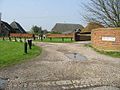 Home Farm, Marshside.jpg 640 × 480; 67 KB
-
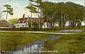 Marshside postcard.jpg 820 × 524; 109 KB
-

-
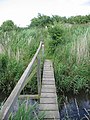
 Bridge over the Whitfield Sewer - geograph.org.uk - 489264.jpg 480 × 640; 83 KB
-

-
 Ditch along Gilling Drove - geograph.org.uk - 372399.jpg 640 × 480; 99 KB
-
 Entrance to Snake Drove - geograph.org.uk - 492238.jpg 640 × 480; 51 KB
-

-
 Gilling Drove, Chislet Marshes - geograph.org.uk - 489008.jpg 480 × 640; 95 KB
-
 Looking N along the North Stream - geograph.org.uk - 492233.jpg 640 × 480; 65 KB
-
 Looking NE along Snake Drove - geograph.org.uk - 489258.jpg 640 × 480; 68 KB
-
 Looking NE along the Wantsum Walk - geograph.org.uk - 489295.jpg 640 × 480; 76 KB
-
 Looking S along North Stream - geograph.org.uk - 492241.jpg 640 × 480; 62 KB
-
 Looking SW along Gilling Drove - geograph.org.uk - 489222.jpg 480 × 640; 73 KB
-
 Rather overgrown Gilling Drove - geograph.org.uk - 489018.jpg 640 × 480; 76 KB
-
 The bridge over Whitfield Sewer - geograph.org.uk - 489215.jpg 480 × 640; 74 KB
-

-
 The chapel, Chapel Lane - geograph.org.uk - 383362.jpg 640 × 480; 41 KB
-
 The Hog and Donkey pub - geograph.org.uk - 383373.jpg 640 × 480; 81 KB
-

-
 View along Chapel Lane - geograph.org.uk - 382552.jpg 640 × 480; 39 KB
-

-
 View along Reynolds Lane - geograph.org.uk - 383503.jpg 640 × 480; 72 KB


