Category:Mariä Himmelfahrt (Altpölla)
Jump to navigation
Jump to search
| Object location | | View all coordinates using: OpenStreetMap |
|---|
| This category shows the protected monument with the number 53176 in Austria. (Commons, de, Wikidata) |
church building in Lower Austria, Austria  | |||||
| Upload media | |||||
| Instance of | |||||
|---|---|---|---|---|---|
| Named after | |||||
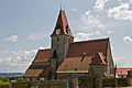
| Location | Pölla, Zwettl District, Lower Austria, Austria | ||||
| Heritage designation | |||||
 | |||||
Media in category "Mariä Himmelfahrt (Altpölla)"
The following 6 files are in this category, out of 6 total.
-
 Kath. Pfarrkirche Mariae Himmelfahrt in Altpölla - Altar.jpg 2,000 × 4,500; 3.08 MB
-
 Kath. Pfarrkirche Mariae Himmelfahrt in Altpölla II.jpg 5,000 × 4,400; 5.39 MB
-
 Kath. Pfarrkirche Mariae Himmelfahrt in Altpölla.jpg 4,500 × 3,000; 3.46 MB
-
 Matthias Laurenz Gräff, Pfarrkirche Mariae Himmelfahrt in Altpölla.jpg 1,438 × 1,915; 410 KB
-
 Pfarrkirche Mariae Himmelfahrt 1, Altpölla.jpg 2,760 × 1,964; 3.38 MB
-
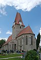 Pfarrkirche Mariae Himmelfahrt 2, Altpölla.jpg 1,731 × 2,531; 3.24 MB


