Category:Margaret Marsh
Jump to navigation
Jump to search
human settlement in United Kingdom  | |||||
| Upload media | |||||
| Instance of | |||||
|---|---|---|---|---|---|
| Location | North Dorset, Dorset, South West England, England | ||||
 | |||||
Subcategories
This category has only the following subcategory.
M
Media in category "Margaret Marsh"
The following 38 files are in this category, out of 38 total.
-
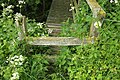 "Stile" onto footbridge over Key Brook - geograph.org.uk - 5123628.jpg 3,072 × 2,048; 1.31 MB
-
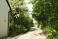
 Along the lane - geograph.org.uk - 2800218.jpg 800 × 600; 150 KB
-
 Benchmark, Marsh Farm - geograph.org.uk - 2800126.jpg 694 × 800; 215 KB
-
 Cattle near Gore Farm - geograph.org.uk - 5126501.jpg 2,943 × 1,856; 1.36 MB
-
 Church Farm, Margaret Marsh - geograph.org.uk - 5124202.jpg 3,059 × 1,576; 1.22 MB
-
 Cut grass field by Green Lane - geograph.org.uk - 5125104.jpg 2,852 × 1,693; 1.03 MB
-
 Farmland near Froghole Farm - geograph.org.uk - 5126631.jpg 2,069 × 1,275; 575 KB
-
 Farmland near Margaret Marsh - geograph.org.uk - 5123624.jpg 3,013 × 1,875; 1.26 MB
-
 Farmland near Margaret Marsh - geograph.org.uk - 5123646.jpg 3,065 × 1,763; 1.66 MB
-
 Field near Froghole Farm - geograph.org.uk - 5126619.jpg 3,072 × 2,048; 1.28 MB
-
 Field near Froghole Farm - geograph.org.uk - 5126650.jpg 3,072 × 2,048; 1.12 MB
-
 Field near Margaret Marsh - geograph.org.uk - 4971349.jpg 3,072 × 1,901; 1.25 MB
-
 Footbridge near Margaret Marsh - geograph.org.uk - 5123488.jpg 2,048 × 3,072; 1.24 MB
-
 Footbridge over Keu Brook - geograph.org.uk - 5123546.jpg 2,900 × 1,945; 1.07 MB
-
 Footpath near Gore Farm - geograph.org.uk - 4971686.jpg 1,920 × 1,280; 744 KB
-
 Gore Farm - geograph.org.uk - 5126601.jpg 3,059 × 1,929; 1.42 MB
-
 Green Lane - geograph.org.uk - 5125026.jpg 3,072 × 2,048; 1.43 MB
-
 Green Lane - geograph.org.uk - 5125128.jpg 3,072 × 2,048; 1.23 MB
-
 Lane past Froghole Farm - geograph.org.uk - 5126645.jpg 3,072 × 2,048; 1.27 MB
-
 Lane past Springreen Cottage - geograph.org.uk - 5126840.jpg 3,072 × 2,048; 1.33 MB
-
 Lane to Elm Farm - geograph.org.uk - 5123456.jpg 3,052 × 1,846; 967 KB
-
 Lane, Margaret Marsh - geograph.org.uk - 5124067.jpg 3,057 × 1,744; 1.22 MB
-
 Lane, Margaret Marsh - geograph.org.uk - 5124316.jpg 2,821 × 1,715; 1.1 MB
-
 Lane, Margaret Marsh - geograph.org.uk - 5124519.jpg 3,072 × 2,048; 1.22 MB
-
 Lane, Margaret Marsh - geograph.org.uk - 5124639.jpg 3,013 × 1,752; 952 KB
-
 Laneside hedge, Margaret Marsh - geograph.org.uk - 5123749.jpg 3,072 × 2,048; 1.42 MB
-
 Lower Farm, Margaret Marsh - geograph.org.uk - 5124647.jpg 2,996 × 1,905; 1.39 MB
-

-

-
 Marsh Farm - geograph.org.uk - 2800135.jpg 3,264 × 2,448; 1.77 MB
-
 Rush hour in Margaret Marsh - geograph.org.uk - 3642369.jpg 640 × 480; 87 KB
-
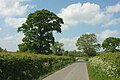
 Towards Higher Farm - geograph.org.uk - 5124310.jpg 3,072 × 1,699; 995 KB
-
 Trees along the Key Brook - geograph.org.uk - 5123635.jpg 3,041 × 1,723; 1.07 MB
-
 Trees near the Key Brook - geograph.org.uk - 5123540.jpg 3,060 × 1,781; 1.08 MB
-
 Elm Farm, near Margaret Marsh - geograph.org.uk - 335980.jpg 640 × 480; 137 KB
-
 Higher Farm near Margaret Marsh - geograph.org.uk - 335887.jpg 640 × 480; 157 KB
-
 Jolliffes Farm near Margaret Marsh - geograph.org.uk - 335977.jpg 640 × 480; 87 KB
-
 Lymburghs Farm near Margaret Marsh - geograph.org.uk - 336001.jpg 640 × 480; 136 KB


