Category:Marais de Goulaine
Jump to navigation
Jump to search
| Object location | | View all coordinates using: OpenStreetMap |
|---|
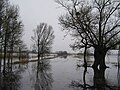
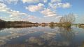
Français : Le Marais de Goulaine est une zone marécageuse protégée, située en rive gauche de la Loire, derrière la levée de la Divatte, partagé par les communes de la Chapelle-Heulin, Haute-Goulaine, le Landreau, le Loroux-Bottereau et Saint-Julien-de-Concelles, dans le département français de la Loire-Atlantique.
English: The swamp of Goulaine is a protected moor located on the left bank of the Loire river, behind the Divatte levee, shared by the municipalities of la Chapelle-Heulin, Haute-Goulaine, le Landreau, le Loroux-Bottereau and Saint-Julien-de-Concelles, in the French department of Loire-Atlantique.
wetland in Loire-Atlantique, France  | |||||
| Upload media | |||||
| Instance of | |||||
|---|---|---|---|---|---|
| Location | |||||
| Heritage designation |
| ||||
| Inflows |
| ||||
| Outflows |
| ||||
| Tributary |
| ||||
| official website | |||||
 | |||||
Subcategories
This category has the following 4 subcategories, out of 4 total.
Media in category "Marais de Goulaine"
The following 11 files are in this category, out of 11 total.
-
 W1375-ChapellHeulin PortMontru 79902.JPG 4,752 × 3,168; 7.49 MB
-
 Haute-Goulaine marais.jpg 3,264 × 2,448; 1.99 MB
-
 Marais landreau.JPG 1,600 × 1,200; 789 KB
-
 Marais de goulaine.JPG 1,600 × 1,200; 402 KB
-
 Noir The Fishing Chair (212475901).jpeg 2,048 × 1,152; 452 KB
-

-
 Photo30020 coucher de soleil depuis le pont de l'ouen.jpg 1,656 × 1,242; 350 KB
-
 W1411-HteGoulaine Marais NiveauxCrues 82711.JPG 4,752 × 3,168; 5.8 MB
-
 W1412-LorouxBottereau Marais Mousse 82726.JPG 4,752 × 3,168; 4.86 MB
-
 W1413-LorouxBottereau Marais Mousse 82731.JPG 4,752 × 3,168; 4.21 MB
-
 W2545 LorouxBottereau PtOuen 20170217-134757N930.jpg 3,072 × 1,728; 1.34 MB


.jpeg)


