Category:Maps showing 1980
Jump to navigation
Jump to search
| ← 1980 1981 1982 1983 1984 1985 1986 1987 1988 1989→ |
English: Maps showing the year 1980 (i.e. history maps)
See also category: 1980 maps. and 1980s maps for old maps created in this time.
See also category: 1980 maps. and 1980s maps for old maps created in this time.
Subcategories
This category has only the following subcategory.
U
Media in category "Maps showing 1980"
The following 7 files are in this category, out of 7 total.
-
 Black Americans 1980 County.png 15,610 × 8,900; 11.66 MB
-
 Cold War Map 1980.svg 940 × 477; 2.29 MB
-
 Crude Birth Rate, 1980.png 1,452 × 1,076; 293 KB
-
 Europe 1980 FlagMap.png 11,589 × 7,635; 3.63 MB
-
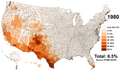 Hispanic Americans 1980 County.png 9,470 × 5,635; 6.79 MB
-
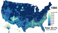
 Non-Hispanic White Americans 1980 County.png 15,610 × 8,900; 16.51 MB
-
 White Americans 1980 County.png 15,610 × 8,900; 10.76 MB


