Category:Maps of weather and climate of the Pacific Ocean
Jump to navigation
Jump to search
Subcategories
This category has the following 15 subcategories, out of 15 total.
*
- North Polar meteorological maps (16 F)
A
C
H
I
J
N
- North Pacific High (4 F)
- North Pacific Oscillation (1 F)
P
T
Media in category "Maps of weather and climate of the Pacific Ocean"
The following 47 files are in this category, out of 47 total.
-
 1939 Eastern Pacific Hurricane Track Map.PNG 5,184 × 4,352; 1.04 MB
-
 1944 SWM WP Two.png 726 × 564; 702 KB
-
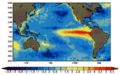
 1997 El Nino TOPEX.jpg 2,550 × 2,548; 556 KB
-
 2009 Dust Storm - Australia and New Zealand Map.png 1,535 × 1,065; 542 KB
-
 Admiralty Chart No 5215 North Pacific Ocean text.jpg 14,621 × 9,940; 15.75 MB
-
 Admiralty Chart No 5215 North Pacific Ocean, Published 1942.jpg 14,702 × 9,940; 8.59 MB
-
 Admiralty Chart No 5216 South Pacific Ocean text.jpg 6,949 × 4,135; 3.41 MB
-
 Admiralty Chart No 5216 South Pacific Ocean, Published 1942.jpg 10,411 × 6,184; 4.02 MB
-
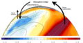 Atmospheric bridge.png 1,256 × 650; 367 KB
-
 Atmospheric River GOES WV 20101220.1200.goes11.vapor.x.pacus.x.jpg 768 × 512; 217 KB
-
 BÃO LÚC 19H NGÀY 2610.gif 1,519 × 919; 70 KB
-
 Cartasinoptica.jpg 391 × 264; 48 KB
-
 Comparing Sea Level During El Niño Events (PIA26099).jpg 1,586 × 783; 589 KB
-
 DesmondAtmosphericRiver.png 1,023 × 526; 596 KB
-
 El ninjo nordamerika vetero.png 529 × 677; 118 KB
-
 El nino north american weather fr.png 529 × 677; 72 KB
-
 El nino north american weather.png 529 × 677; 64 KB
-
 El Niño, Dic 1997.png 447 × 281; 65 KB
-
 El-Nino-secheresse.pdf 1,370 × 660; 87 KB
-
 El-nino.png 576 × 277; 113 KB
-
 Enso-index-map.png 918 × 305; 8 KB
-
 Ĉefcirkla ŝprucflua kursoj.png 800 × 367; 56 KB
-
 Greatcircle Jetstream routes mk.svg 815 × 374; 92 KB
-
 Greatcircle Jetstream routes.svg 815 × 374; 54 KB
-
 Hurricane Linda 5-day forecast 8 p.m. PDT.gif 895 × 716; 24 KB
-
 La Nina and Pacific Decadal Anomalies - April 2008.png 709 × 553; 487 KB
-
 LaNina Pacific 2006JanFeb.jpg 540 × 465; 109 KB
-
 Mean sst equatorial pacific.gif 432 × 645; 24 KB
-
 Mjo north america rain.png 556 × 749; 28 KB
-
 Movement of surface waters during El Nino.jpg 2,512 × 1,286; 330 KB
-
 Nepac sst oper0-Temp-sup-Oc-Pacífico-16-sep-2013.png 1,024 × 768; 160 KB
-
 Nino.gif 308 × 133; 8 KB
-
 Ocean circulation near New Zealand.tif 2,060 × 2,621; 4.74 MB
-
 Shamal1 en.jpg 819 × 730; 218 KB
-
 Shamal2 pl.jpg 819 × 730; 214 KB
-
 Sst 9798 animated.gif 432 × 282; 876 KB
-
 Sstaanim.gif 486 × 234; 113 KB
-
 Stiller ozean.jpg 4,555 × 3,956; 7.07 MB
-
 Streamlineanalysispacific.gif 1,000 × 600; 36 KB
-
 Unnamed typhoon on April 10, 1938.png 771 × 646; 573 KB
-
 Unnamed typhoon on May 3, 1938.png 694 × 585; 520 KB
-
 WaterVapor.jpg 553 × 600; 40 KB
-
 Weathermap eastasia 1.png 1,200 × 800; 83 KB
-
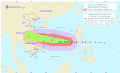
 Wp052012.12061512.gif 955 × 640; 45 KB
-
 Wp0814W track.gif 620 × 374; 43 KB
-
 Wp222020.20201031073936.gif 1,122 × 709; 100 KB
-
 Wp9614.gif 1,112 × 789; 24 KB


.jpg)


