Category:Maps of tides
Jump to navigation
Jump to search
Subcategories
This category has only the following subcategory.
Media in category "Maps of tides"
The following 44 files are in this category, out of 44 total.
-
 245 of 'Elementary Physical Geography' (11238529254).jpg 1,429 × 2,102; 737 KB
-
 AdmoraltyvChart No 5059 Straits of Dover Co-tidal and Tidal Stream Chart, Published 1943.jpg 16,407 × 11,265; 45.28 MB
-
 Amfidromieen.JPG 300 × 346; 114 KB
-
 Amfidromieën.jpg 300 × 346; 608 KB
-
 Arctic tides (1911) (14760115061).jpg 4,016 × 3,348; 2.51 MB
-

-
-

-

-

-

-

-
 Beechey Tidal Chart of the Irish Channel dated 1846.tiff 4,016 × 6,142; 1.56 MB
-
 Beechey Tide Chart of the English, Irish and Bristol Channels Ingoing dated 1848.tif 8,325 × 4,061; 1.65 MB
-
 Beechey Tide Chart of the English, Irish and Bristol Channels Outgoing dated 1848.tif 8,226 × 4,079; 1.65 MB
-
 Cotid mancheSodi.svg 573 × 518; 215 KB
-
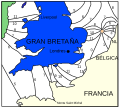
 Cotidal map tide round Great Britain Lubbock 1831 2.png 3,111 × 5,956; 7.2 MB
-
 Cotidal-lines-tide-height.jpg 600 × 403; 64 KB
-
 Cotidal-lines-world.jpg 1,269 × 759; 218 KB
-
 Diurnal tide types map.jpg 855 × 420; 125 KB
-
 Elementary physical geography (1907) (14585502127).jpg 1,498 × 2,386; 788 KB
-
 FMIB 43870 Co-tidal Lines of the British Isles.jpeg 913 × 1,274; 270 KB
-
 FMIB 43874 Tides of the English Channel.jpeg 891 × 555; 135 KB
-
 FMIB 43876 Course of the Tide in the Irish Sea.jpeg 883 × 985; 249 KB
-
Global surface elevation of M2 ocean tide.webm 31 s, 1,920 × 1,080; 5.77 MB
-
 Locais com marés superiores à 5 m de altura.jpg 559 × 315; 48 KB
-
 M2 tidal constituent.jpg 730 × 470; 122 KB
-
 M2 Tidal constituent.tif 6,142 × 3,567; 4.68 MB
-
 PSM V74 D535 Systems of semi daily tides around the world based on gmt.png 2,877 × 1,637; 1.2 MB
-
 PSM V74 D537 Cotidal lines of the atlantic ocean.png 2,016 × 3,226; 1,024 KB
-
 PSM V74 D538 Cotidal lines of the indian ocean.png 1,920 × 3,237; 823 KB
-
 PSM V74 D539 Cotidal lines of the pacific ocean.png 1,931 × 3,242; 991 KB
-
 PSM V74 D540 Cotidal lines for new york harbor and approaches.png 2,406 × 1,631; 342 KB
-
 The elements of astronomy; a textbook (1919) (14779879304).jpg 3,120 × 1,952; 1.16 MB
-
 Tide over 4 m.png 1,357 × 628; 64 KB
-
 Tides in Norway.png 1,225 × 2,510; 113 KB
-
 Whewell co-tidal chart 1.tif 2,537 × 3,856; 18.74 MB
-
 Whewell co-tidal chart 2.tif 3,840 × 4,905; 33.86 MB
-
 Whewell tidal chart Britain and Ireland 1836 amphidromic point southern North Sea.jpg 1,490 × 1,292; 487 KB
-
 Whewell tidal chart Britain and Ireland 1836.jpg 7,610 × 6,704; 4.4 MB
-
 Whewell tidal chart coasts of Europe 1836.jpg 3,189 × 5,430; 1.48 MB
-
 Whewell tidal chart Pacific 1848.jpg 3,872 × 3,396; 1.86 MB
-
 Whewell tidal chart World 1833 07023587 0090.jpg 23,281 × 10,627; 31.24 MB
-
 Whewell tidal height chart Britain and Ireland 1836.jpg 8,004 × 7,259; 4.11 MB
.jpg)


_(14760115061).jpg)


_(14585502127).jpg)


_(14779879304).jpg)


