Category:Maps of the history of departments of France
Jump to navigation
Jump to search
Countries of Europe: France‡
Use the appropriate category for maps showing all or a large part of regions of France. See subcategories for smaller areas:
| If the map shows | Category to use |
|---|---|
| regions of France on a recently created map | Category:Maps of departments of France or its subcategories |
| regions of France on a map created more than 70 years ago | Category:Old maps of departments of France or its subcategories |
| the history of regions of France on a recently created map | Category:Maps of the history of departments of France or its subcategories |
| the history of regions of France on a map created more than 70 years ago | Category:Old maps of the history of departments of France or its subcategories |

Departments of Metropolitan France: Ain [01] · Aude [11] · Bouches-du-Rhône [13] · Dordogne [24] · Haute-Garonne [31] · Oise [60] · departmental district of the Rhône [69] · Savoie [73] · Paris [75] · Seine-Maritime [76]
Overseas departments and regions: Guadeloupe [971] · Réunion [974]
Overseas departments and regions: Guadeloupe [971] · Réunion [974]
Subcategories
This category has the following 14 subcategories, out of 14 total.
- Maps of the history of Aude (2 F)
- Maps of the history of Rhône (4 F)
'
+
- Maps of the history of Réunion (16 F)
Media in category "Maps of the history of departments of France"
The following 17 files are in this category, out of 17 total.
-
 1789 + 2022 Auvergne-Rhône-Alpes, noms.png 1,416 × 1,209; 206 KB
-
 1789 + 2022 Bourgogne-Franche-Comté, noms.png 1,451 × 1,290; 222 KB
-
 1789 + 2022 Bretagne, noms.png 1,135 × 873; 101 KB
-
 1789 + 2022 France, noms des régions.png 4,264 × 4,098; 1.34 MB
-
 1789 + 2022 Grand Est, noms.png 1,583 × 1,125; 210 KB
-
 1789 + 2022 Hauts-de-France + Île, noms.png 866 × 1,378; 136 KB
-
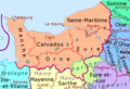 1789 + 2022 Normandie, noms.png 1,228 × 836; 117 KB
-
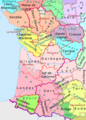 1789 + 2022 Nouvelle Aquitaine, noms.png 1,361 × 1,895; 277 KB
-
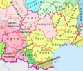 1789 + 2022 Occitanie, noms.png 1,483 × 1,260; 204 KB
-
 1789 + 2022 Pays de la Loire, noms.png 1,130 × 1,134; 150 KB
-
 1789 + 2022 Provence, noms.png 984 × 914; 100 KB
-
 1789 et 2022, Centre-Val de Loire et Île-de-France, noms.png 1,200 × 1,368; 188 KB
-
 Carte 134 départements.png 800 × 1,013; 636 KB
-
 Départements 1919.jpg 945 × 1,122; 115 KB
-
 Départements et provinces de France.png 1,785 × 1,670; 310 KB
-
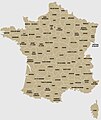
 France 1789 + 2022.png 4,264 × 4,098; 1.26 MB
-
 SOS Territories in WW I.png 507 × 553; 85 KB


