Category:Maps of the Gambier Islands
Jump to navigation
Jump to search
Media in category "Maps of the Gambier Islands"
The following 22 files are in this category, out of 22 total.
-
 1799 published Gambier Island map by James Wilson of ship Duff.jpg 3,915 × 2,973; 1.57 MB
-
 186 of '(The Geological Observer.)' (11230313164).jpg 1,320 × 1,385; 518 KB
-
 210 of '(The Geological Observer.)' (11233218194).jpg 1,341 × 1,406; 628 KB
-

-
 241 of 'The Geological Observer' (11230875676).jpg 1,322 × 1,383; 606 KB
-

-
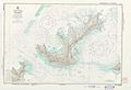
 Admiralty Chart No 1112 Gambier Group, Surveyed by Beechey 1826, Published 1831.jpg 5,967 × 6,113; 3.98 MB
-

-

-
 Gambier Inseln png.png 720 × 540; 86 KB
-
 Gambier Islands 1826 map by Beechey.jpg 5,967 × 6,113; 3.98 MB
-
 Gambier Islands 1838 map.jpg 5,705 × 7,321; 5.99 MB
-
 Gambier mk.png 1,633 × 1,688; 623 KB
-
 Gambier9.png 1,633 × 1,688; 533 KB
-
 Karta FP Gambier isl.PNG 450 × 400; 5 KB
-
 Mangareva 1974 nautical chart with traditional districts added.jpg 8,766 × 6,016; 9.61 MB
-
 Mangareva 1974 nautical chart.jpg 8,766 × 6,016; 8.65 MB
-
-
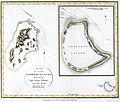
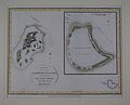 Map of the Gambier Islands and of Prospect Island (Temoe Atoll) by Capt. James Duff.jpg 3,063 × 2,477; 604 KB
-
 Pacific Ocean laea Oceanian countries map.jpg 1,165 × 1,070; 542 KB
-
 Temoe Map Names.png 1,240 × 902; 237 KB
-
 Temoe Map.jpg 1,240 × 902; 200 KB

%27_(11230313164).jpg)
%27_(11233218194).jpg)
.jpg)
.jpg)
_On_Coral_Reefs_and_Islands_..._From_the_author%27s_Exploring_Expedition_Report_on_Geology,_with_additions%27_(11042506345).jpg)

,_Published_1831.jpg)


_by_Capt_James_Duff_(retouched).jpg)
_by_Capt._James_Duff.jpg)


