Category:Maps of the Enceinte de Thiers
Jump to navigation
Jump to search
Media in category "Maps of the Enceinte de Thiers"
The following 13 files are in this category, out of 13 total.
-
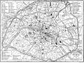 Britannica Paris.jpg 1,173 × 877; 371 KB
-
 Britannica Paris.png 2,927 × 2,172; 536 KB
-
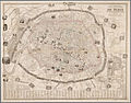 Bénard, Nouveau plan illustré de la ville de Paris, 1857.jpg 4,364 × 3,436; 3.37 MB
-
 Henri Dron & Heymann, Plan de la Commune de Paris - Paris Musées.jpg 7,790 × 6,029; 29.14 MB
-
 Illustrirte Zeitung (1843) 15 229 1 Plan der Befestigung von Paris.PNG 1,504 × 1,194; 847 KB
-
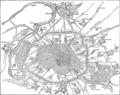
 LPDF 16 8 carte de la défense de Paris.jpg 478 × 483; 196 KB
-
 Paris PC 1859 jms.jpg 5,820 × 4,968; 6.28 MB
-
 Plan des anciennes enceintes de Paris (1180-1845) - Paris Musées.jpg 9,262 × 6,876; 40.55 MB
-

-
 Plan des anciennes enceintes et limites de Paris, Etabli par A. Grimault (02) - Paris Musées.jpg 8,463 × 6,108; 31.94 MB
-
 Plan des anciennes enceintes et limites de Paris, Etabli par A. Grimault (03) - Paris Musées.jpg 8,216 × 6,152; 32.71 MB
-
 The city limits of Paris from the 4th century to 2015.svg 1,500 × 1,000; 24 KB
-
 Tracé rue d'Enfer en 1857.jpg 521 × 609; 108 KB


_15_229_1_Plan_der_Befestigung_von_Paris.PNG)


_-_Paris_Mus%C3%A9es.jpg)
_-_Paris_Mus%C3%A9es.jpg)
_-_Paris_Mus%C3%A9es.jpg)
_-_Paris_Mus%C3%A9es.jpg)

