Category:Maps of the Borough of Bournemouth
Jump to navigation
Jump to search
English: Maps of the former Bournemouth district, now in Bournemouth, Christchurch and Poole district, in the ceremonial county of Dorset, England.
Media in category "Maps of the Borough of Bournemouth"
The following 10 files are in this category, out of 10 total.
-
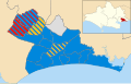 Bournemouth Borough Council election 2011 map.svg 1,425 × 904; 265 KB
-
 Bournemouth in England (special marker).svg 816 × 991; 1.32 MB
-
 Bournemouth in England (zoom).svg 816 × 991; 1.34 MB
-
 Bournemouth in England.svg 816 × 991; 1.32 MB
-
 Bournemouth UK local election 2003 map.svg 1,425 × 904; 264 KB
-
 Bournemouth UK local election 2007 map.svg 1,425 × 904; 264 KB
-
 Bournemouth UK local election 2015 map.svg 1,425 × 904; 264 KB
-
 Bournemouth UK locator map.svg 1,425 × 990; 909 KB
-
 Bournemouth UK ward map 2010 (blank).svg 1,425 × 904; 263 KB
-
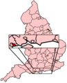 EnglandBournemouth.png 200 × 247; 28 KB

.svg)
.svg)


.svg)