Category:Maps of the Bay of Kotor
Jump to navigation
Jump to search
Subcategories
This category has the following 5 subcategories, out of 5 total.
Media in category "Maps of the Bay of Kotor"
The following 30 files are in this category, out of 30 total.
-
 ...Versincken ende verbranden vande stadt Ragousa (BM 1873,0809.1515).jpg 2,500 × 1,743; 1.34 MB
-
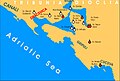
 Albania veneta.png 537 × 613; 76 KB
-
 Balsa II Balsic i Kotor u XIV v.png 828 × 604; 123 KB
-
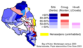 Bay of Kotor ethnic map 2003.png 1,500 × 880; 90 KB
-
 Bay of Kotor map.jpg 540 × 661; 92 KB
-
 Bay of Kotor maps.jpg 1,500 × 1,058; 271 KB
-
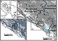
 Bay of Kotor Orjen glacial traces.jpg 1,500 × 1,500; 495 KB
-
 Boka Kotor Montenegroetn2003.png 1,300 × 967; 62 KB
-
 Boka Kotorska Montenegro census2003.png 1,290 × 886; 107 KB
-
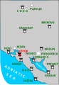
 Boka Kotorska zupe u srednjem vijeku.jpg 999 × 678; 215 KB
-
 Budva Kotor blank map.svg 744 × 1,052; 6 KB
-
 Churches in the Bay of Kotor-es.svg 753 × 511; 338 KB
-
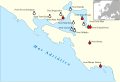
 Churches in the Bay of Kotor.jpg 999 × 678; 197 KB
-
 Churches in the Bay of Kotor.svg 753 × 511; 57 KB
-
 Dracevica zupa.jpg 999 × 678; 215 KB
-
 Draceviza zupa.svg 691 × 677; 6 KB
-
 ETH-BIB-Boka Kotorska, Karte-Dia 247-10259.tif 3,892 × 2,475; 27.65 MB
-
 Gripuli and Cuceva zupe.png 677 × 749; 96 KB
-
 Herceg Novi map.png 2,514 × 2,548; 1.95 MB
-
 Herceg novi na karti.jpg 749 × 513; 89 KB
-
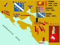 Kotor and Balsa II Balsic XIV cAD.svg 800 × 600; 283 KB
-
 Kotor medieval fortress position.svg 215 × 309; 15 KB
-
 Krtoljski arhipelag.jpg 686 × 556; 110 KB
-
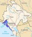
 Montenegro venezia.PNG 537 × 613; 56 KB
-
 Venezia Montenegro.svg 479 × 583; 3.38 MB
-
 Orjen location.jpg 640 × 640; 310 KB
-
 Preromanske crkvene gradjevine u Boki Kotorskoj 2.jpg 999 × 678; 194 KB
-
 Preromanske crkvene gradjevine u Boki Kotorskoj.jpg 999 × 678; 149 KB
-
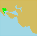
 Vicinity-of-Prevlaka-in-Croatia-and-Montenegro hu.png 1,648 × 1,269; 626 KB
-
 Vicinity-of-Prevlaka-in-Croatia-and-Montenegro.PNG 1,236 × 952; 80 KB
.jpg)


