Category:Maps of rivers of the Central African Republic
Jump to navigation
Jump to search
Media in category "Maps of rivers of the Central African Republic"
The following 15 files are in this category, out of 15 total.
-
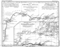
 Carte du voyage de Mgr Carrie de Loango à l'Ubanghi.jpg 1,289 × 1,054; 299 KB
-
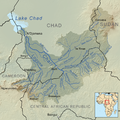 Charirivermap.png 1,001 × 1,000; 1.46 MB
-
 Congo-Mubangi-1908.jpg 472 × 760; 89 KB
-
 Les Abiras.jpg 473 × 264; 27 KB
-
 Mambere.jpg 538 × 620; 82 KB
-
 Map Ubangi-Uelle 1888.png 3,980 × 3,144; 2.62 MB
-
 OSM-LaSangha.png 974 × 712; 249 KB
-
 OSM-LeChari.png 974 × 709; 356 KB
-
 Pende çayı 2014-04-21 17-54.png 300 × 300; 176 KB
-
 Sangha Basin OSM.png 3,728 × 5,007; 33.19 MB
-
 Sangha OSM.png 3,469 × 3,339; 20.86 MB
-
 Sanghabasinmap.png 1,441 × 1,793; 1.97 MB
-
 Sudan FrenchWestAfrica Border 1922.png 815 × 1,134; 153 KB
-
 Ubangirivermap.png 996 × 767; 1.16 MB
-
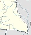
 Zentralafrikanische-republik-karte-politisch.png 567 × 411; 162 KB


