Category:Maps of islands of Var
Jump to navigation
Jump to search
Media in category "Maps of islands of Var"
The following 5 files are in this category, out of 5 total.
-
 Porquerolles topographic map-fr.svg 1,027 × 723; 1.15 MB
-
 Port-Cros topographic map-fr.svg 1,428 × 951; 591 KB
-
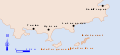 Île du Levant localisation.svg 870 × 398; 19 KB
-
 Île du Levant topographic map-fr.svg 1,623 × 1,247; 982 KB
-
 Îles d'Hyères topographic map-fr.svg 784 × 337; 1.84 MB


