Category:Maps of constituencies of Iceland
Jump to navigation
Jump to search
Subcategories
This category has the following 2 subcategories, out of 2 total.
M
- Maps of Suðurkjördæmi (2 F)
- Maps of Suðvesturkjördæmi (2 F)
Media in category "Maps of constituencies of Iceland"
The following 19 files are in this category, out of 19 total.
-
 Constituencies Iceland it.png 457 × 336; 148 KB
-
 Constituencies Iceland pl.png 457 × 336; 121 KB
-
 Constituencies Iceland pt.png 457 × 336; 144 KB
-
 Constituencies Iceland ru.png 457 × 336; 130 KB
-
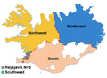 Constituencies Iceland.png 457 × 336; 136 KB
-
 Distritos Islandia.png 457 × 336; 115 KB
-
 Islanda - Distretti elettorali.png 501 × 373; 39 KB
-
 Kjördæmaskipting Íslands.svg 842 × 595; 4.3 MB
-
 Kjördæmi Íslands.png 507 × 373; 154 KB
-
 Nordausturkjordaemi.png 501 × 373; 15 KB
-
 Nordvesturkjordaemi.png 501 × 373; 17 KB
-
 Norðausturkjördæmi.png 1,600 × 1,171; 390 KB
-
 Norðvesturkjördæmi.png 1,534 × 1,283; 501 KB
-
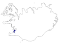 Reykjavikurkjordaemi.png 501 × 373; 13 KB
-
 Reykjavík norður.png 1,500 × 1,352; 221 KB
-
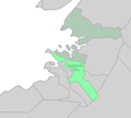 Reykjavík suður.png 1,500 × 1,352; 220 KB
-
 Sudurkjordaemi.png 501 × 373; 19 KB
-
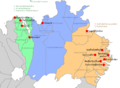
 Sveitarfélög-Kjördæmi.png 800 × 589; 255 KB
-
 Wahlkreise in Island.svg 815 × 499; 206 KB


