Category:Maps of cities in Denmark
Jump to navigation
Jump to search
Countries of Europe: Austria · Azerbaijan‡ · Belarus · Bosnia and Herzegovina · Bulgaria · Croatia · Czech Republic · Denmark · Estonia · Finland · France‡ · Georgia‡ · Germany · Greece · Hungary · Iceland · Italy · Kazakhstan‡ · Latvia · Lithuania · Moldova · Montenegro · Netherlands‡ · North Macedonia · Norway · Poland · Portugal‡ · Romania · Russia‡ · Slovakia · Spain‡ · Sweden · Switzerland · Turkey‡ · Ukraine · United Kingdom
Limited recognition: Abkhazia‡ · Kosovo · South Ossetia‡
‡: partly located in Europe
Limited recognition: Abkhazia‡ · Kosovo · South Ossetia‡
‡: partly located in Europe
Subcategories
This category has the following 16 subcategories, out of 16 total.
A
- Location of towns near Aarhus (51 F)
C
E
- Maps of Esbjerg (6 F)
F
- Maps of Fredericia (3 F)
H
- Maps of Hadsten (11 F)
- Maps of Hadsund (27 F)
- Maps of Hillerød (5 F)
- Maps of Hjørring (4 F)
K
- Maps of Køge (10 F)
M
- Maps of Korsør (3 F)
- Maps of Lemvig (3 F)
N
- Maps of Næstved (2 F)
O
R
S
- Maps of Skagen (4 F)
Media in category "Maps of cities in Denmark"
The following 19 files are in this category, out of 19 total.
-
 -Nykøbingfalster 1900.jpg 1,071 × 1,064; 742 KB
-
 Aalborg-Nørresundby map.png 1,154 × 1,080; 1.13 MB
-
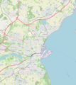 Aarhus map.png 1,232 × 1,376; 1.41 MB
-
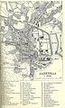 Aabenraa 1923.jpg 1,352 × 2,255; 2.5 MB
-
 Bymuseet Fredericia 02.JPG 2,560 × 1,920; 2.94 MB
-
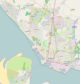 Esbjerg 2015 OSM.png 690 × 722; 355 KB
-
 Ginneruplundbydel.png 489 × 434; 249 KB
-
 Hadsund by kort.png 1,956 × 1,962; 1.4 MB
-
 Herning map.png 2,187 × 1,820; 2.8 MB
-
 Kolding map.png 1,794 × 2,179; 2.9 MB
-
 Nysted kloster.jpg 702 × 701; 114 KB
-
 Omkring Hadsten.png 583 × 451; 237 KB
-
 Placering 1.JPG 1,130 × 805; 105 KB
-
 Randers map.png 805 × 832; 503 KB
-
 Skjoldhøj kollegiet fra oven.png 636 × 419; 111 KB
-
 Soenderborg 1925.jpg 1,317 × 2,205; 2.42 MB
-
 Vejle map.png 596 × 747; 338 KB
-
 Viborg map 1700s.JPG 3,056 × 2,168; 3.1 MB
-
 Vold 1798.JPG 569 × 422; 71 KB


