Category:Maps of borders of Honduras
Jump to navigation
Jump to search
Media in category "Maps of borders of Honduras"
The following 19 files are in this category, out of 19 total.
-
 Caribbean maritime boundaries map zh.svg 3,561 × 2,221; 2.87 MB
-
 Caribbean maritime boundaries map.svg 3,561 × 2,221; 2.78 MB
-
 Caribbean maritime boundaries map mk.svg 3,561 × 2,221; 5.52 MB
-
 Mapa das Caraíbas (fronteiras marítimas).svg 3,561 × 2,221; 2.86 MB
-
 Mapa del Caribe (límites marinos).svg 5,340 × 3,660; 3.02 MB
-
 Mapa del Mar Caribe (límites marinos)-fr.svg 3,587 × 2,221; 1.91 MB
-
 Mapa del Mar Caribe (límites marinos).svg 3,587 × 2,221; 1.98 MB
-
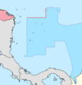 Colombie-Honduras.png 949 × 994; 98 KB
-
 Frontera Honduras Mexico.png 838 × 852; 74 KB
-
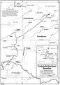 Guatemala-Honduras border.png 856 × 1,194; 355 KB
-
 Honduras-Nicaragua border 1.png 1,026 × 1,258; 187 KB
-
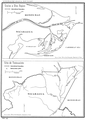 Honduras-Nicaragua border 2.png 852 × 1,189; 294 KB
-
 Honduras-Nicaragua border map.png 433 × 419; 34 KB
-

-

-

-
 Map of the disputed territory between Nicaragua and Honduras.jpg 1,350 × 2,000; 551 KB
-
 Mapa A Fallo Litigio Nicaragua-Colombia.svg 1,057 × 996; 273 KB
-
 Mapa B Fallo Litigio Nicaragua-Colombia.svg 1,057 × 996; 297 KB


.svg)
.svg)
-fr.svg)
.svg)


_Course_of_the_maritime_boundary_(es).svg)
_Course_of_the_maritime_boundary.svg)


