Category:Maps of Vistula
Jump to navigation
Jump to search
Wikimedia category | |||||
| Upload media | |||||
| Instance of | |||||
|---|---|---|---|---|---|
| Category combines topics | |||||
| Vistula | |||||
river in East-Central Europe   | |||||
| Instance of | |||||
| Location | Lesser Poland Voivodeship, Poland | ||||
| Has part(s) | |||||
| Length |
| ||||
| Origin of the watercourse | |||||
| Mouth of the watercourse | |||||
| Drainage basin | |||||
| Basin country | |||||
| Tributary |
| ||||
| Lake on watercourse | |||||
| Different from | |||||
 | |||||
Subcategories
This category has the following 4 subcategories, out of 4 total.
Pages in category "Maps of Vistula"
This category contains only the following page.
Media in category "Maps of Vistula"
The following 50 files are in this category, out of 50 total.
-
 1657 Jansson Map of Germany (Germania) - Geographicus - Germaniae-jansson-1657.jpg 3,500 × 2,811; 3.38 MB
-
 1832 Delamarche Map of Germany in Roman Times - Geographicus - Germany-d-32.jpg 3,000 × 2,537; 2.01 MB
-
 Ancient Germania - New York, Harper and Brothers 1849.jpg 1,964 × 1,619; 841 KB
-
 Bicurgium.jpg 536 × 439; 259 KB
-
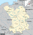 CuencaDelVístula.svg 656 × 685; 5.31 MB
-
 Entwerffung 0414.028.007 front.tif 10,058 × 7,274; 141.02 MB
-
 Karte Weichsel.jpg 426 × 400; 48 KB
-
 Map of Europe according to Strabo.jpg 485 × 385; 152 KB
-
 Mapa Beltrama ok 1300 .jpg 656 × 492; 99 KB
-
 Merian Schwedische Schantz.jpg 1,200 × 983; 280 KB
-
 Munitio Insulae Passerinae 0414.028.009 front.tif 10,101 × 7,308; 132.69 MB
-

-
 Sveriges Krig 2.39 front.tif 11,794 × 4,890; 109.3 MB
-
 Vistula Map.png 370 × 370; 9 KB
-
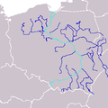
 Vistula river map hu.svg 1,333 × 1,440; 1.51 MB
-
 Vistula river map-clean.png 1,000 × 1,080; 436 KB
-
 Vistula river map-Hebrew.svg 1,000 × 1,080; 1.3 MB
-
 Vistula river map.png 1,000 × 1,080; 1.17 MB
-
 Weichseldelta.png 1,700 × 2,340; 116 KB
-
 Weichseldurchstich.png 1,700 × 2,340; 123 KB
-
 Dzieje Krakowa 1911 (8514430) (cropped).jpg 1,178 × 1,421; 990 KB
-
 Dzieje Krakowa 1911 (8514454) (cropped).jpg 2,393 × 1,120; 1.1 MB
-

-
-

-
-

-

-

-

-

-

-
-

-

-

-

-

-

-

-

-

-

-
-

-

-

-

-

-

_-_Geographicus_-_Germaniae-jansson-1657.jpg)


_(BM_1870,1112.207).jpg)


_(cropped).jpg)
_(cropped).jpg)
.jpg)
.jpg)
.jpg)
.jpg)
.jpg)
.jpg)
.jpg)
.jpg)
.jpg)
.jpg)
.jpg)
.jpg)
.jpg)
.jpg)
.jpg)
.jpg)
.jpg)
.jpg)
.jpg)
.jpg)
.jpg)
.jpg)
.jpg)
.jpg)
.jpg)
.jpg)
.jpg)
.jpg)