Category:Maps of Suceava County
Jump to navigation
Jump to search
Counties of Romania: Alba · Arad · Argeș · Bacău · Bihor · Bistrița-Năsăud · Botoșani · Brașov · Brăila · Buzău · Caraș-Severin · Cluj · Constanța · Covasna · Călărași · Dolj · Dâmbovița · Galați · Giurgiu · Gorj · Harghita · Hunedoara · Ialomița · Iași · Ilfov · Maramureș · Mehedinți · Mureș · Neamț · Olt · Prahova · Sălaj · Satu Mare · Sibiu · Suceava · Teleorman · Timiș · Tulcea · Vâlcea · Vaslui · Vrancea – Capital city: Bucharest
Wikimedia category | |||||
| Upload media | |||||
| Instance of | |||||
|---|---|---|---|---|---|
| Category combines topics | |||||
| Suceava County | |||||
county of Romania    | |||||
| Instance of |
| ||||
| Location | Romania | ||||
| Capital | |||||
| Legislative body |
| ||||
| Inception |
| ||||
| Population |
| ||||
| Area |
| ||||
| official website | |||||
 | |||||
Subcategories
This category has the following 17 subcategories, out of 17 total.
B
- Maps of Broșteni (2 F)
C
- Maps of Cajvana (2 F)
D
- Maps of Dolhasca (2 F)
F
- Maps of Fălticeni (2 F)
- Maps of Frasin (2 F)
G
- Maps of Gura Humorului (2 F)
L
- Maps of Liteni (2 F)
M
- Maps of Milișăuți (2 F)
R
- Maps of Rădăuți (2 F)
S
- Maps of Salcea (2 F)
- Maps of Siret (2 F)
- Maps of Solca (2 F)
- Maps of Suceava (6 F)
V
- Maps of Vatra Dornei (2 F)
- Maps of Vicovu de Sus (2 F)
Media in category "Maps of Suceava County"
The following 18 files are in this category, out of 18 total.
-
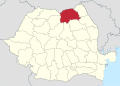
 Suceava.png 283 × 214; 9 KB
-
 Suceava.svg 1,300 × 1,000; 290 KB
-
 Suceava County.svg 1,958 × 1,380; 1.05 MB
-
 Suceava in Romania.svg 1,611 × 1,152; 815 KB
-
 Judetul Suceava 3D map.jpg 1,062 × 764; 537 KB
-
 Provinz Suceava Romania CIA2006.png 500 × 500; 649 KB
-
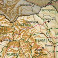
 Harta jud Suceava.png 400 × 317; 83 KB
-
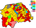 Harta locale primari suceava 2020.png 1,544 × 1,210; 683 KB
-
 Map of Churches of Moldavia in Suceava Country.jpg 5,200 × 3,536; 864 KB
-
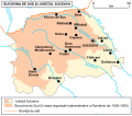 Map of cities in Suceava County and Southern Bukovina.svg 900 × 790; 418 KB
-
 Map of monasteries in Suceava County.jpg 617 × 454; 37 KB
-
 Map of Poles in Suceava County and Southern Bukovina.png 752 × 597; 215 KB
-
 P 2012.png 400 × 317; 30 KB
-
 P2 2012.png 600 × 517; 175 KB
-
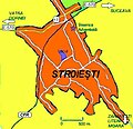
 Stroiesti map1.png 411 × 371; 94 KB
-
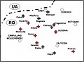
 Stroiesti map2.jpg 477 × 461; 77 KB
-
 Stroiesti map3.jpg 477 × 461; 74 KB
-
 Stroiesti-suceava-local-map.jpg 900 × 727; 175 KB


