Category:Maps of Subdivisions of East Timor (with borders since 2015)
Jump to navigation
Jump to search
Subcategories
This category has only the following subcategory.
Media in category "Maps of Subdivisions of East Timor (with borders since 2015)"
The following 37 files are in this category, out of 37 total.
-
 2015 Ainaro beschriftet.png 1,956 × 3,208; 785 KB
-
 2015 Baucau beschriftet.png 4,492 × 2,117; 1.11 MB
-
 2015 East Timor Aileu locator map.png 3,344 × 1,929; 177 KB
-
 2015 East Timor Ainaro locator map.png 3,344 × 1,929; 177 KB
-
 2015 East Timor Baucau locator map.png 3,344 × 1,929; 177 KB
-
 2015 East Timor Bobonaro locator map.png 3,344 × 1,929; 177 KB
-
 2015 East Timor Cova Lima locator map.png 3,344 × 1,929; 176 KB
-
 2015 East Timor Ermera locator map.png 3,344 × 1,929; 177 KB
-
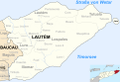
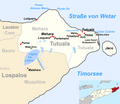
 2015 East Timor Lautem locator map.png 3,344 × 1,929; 177 KB
-
 2015 East Timor Liquica locator map.png 3,344 × 1,929; 176 KB
-
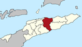 2015 East Timor Manatuto locator map.png 3,344 × 1,929; 177 KB
-
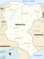
 2015 East Timor Manufahi locator map.png 3,344 × 1,929; 177 KB
-
 2015 East Timor Oecusse locator map.png 3,344 × 1,929; 176 KB
-
 2015 East Timor Viqueque locator map.png 3,344 × 1,929; 177 KB
-
 2015 Lautém beschriftet.png 4,380 × 3,017; 897 KB
-
 2015 Manatuto beschriftet.png 3,061 × 4,019; 1.23 MB
-
 2015 Manatuto beschriftet.tif 3,061 × 4,019; 35.2 MB
-
 2015 Tutuala Verwaltungsamt.png 1,903 × 1,650; 522 KB
-
 2015 Viqueque beschriftet.png 4,671 × 2,521; 1.06 MB
-
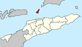 2022 East Timor Atauro locator map.png 3,344 × 1,929; 175 KB
-
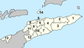
 2022 East Timor Dili locator map.png 3,344 × 1,929; 176 KB
-
 2022 East Timor municipalities numbers.png 3,344 × 1,929; 222 KB
-
 2022 East Timor, administrative divisions - de - colour.tif 3,344 × 1,929; 18.46 MB
-
 2022 East Timor, administrative divisions - de - monochrom.tif 3,344 × 1,929; 18.46 MB
-
 Map of Timor-Leste - administrative (since 2015) - Município of Aileu.png 2,500 × 2,006; 393 KB
-
 Map of Timor-Leste - administrative (since 2015) - Município of Ainaro.png 1,956 × 3,208; 427 KB
-
 Map of Timor-Leste - administrative (since 2015) - Município of Baucau.png 4,492 × 2,117; 601 KB
-
 Map of Timor-Leste - administrative (since 2015) - Município of Bobonaro.png 3,401 × 3,260; 684 KB
-
 Map of Timor-Leste - administrative (since 2015) - Município of Covalima.png 3,800 × 3,083; 617 KB
-
 Map of Timor-Leste - administrative (since 2015) - Município of Ermera.png 2,303 × 2,419; 460 KB
-
 Map of Timor-Leste - administrative (since 2015) - Município of Lautém.png 4,380 × 3,017; 497 KB
-
 Map of Timor-Leste - administrative (since 2015) - Município of Liquiçá.png 3,057 × 1,456; 327 KB
-
 Map of Timor-Leste - administrative (since 2015) - Município of Manatuto.png 3,061 × 4,019; 780 KB
-
 Map of Timor-Leste - administrative (since 2015) - Município of Manufahi.png 3,229 × 3,296; 640 KB
-
 Map of Timor-Leste - administrative (since 2015) - Município of Oecusse.png 3,133 × 2,558; 215 KB
-
 Map of Timor-Leste - administrative (since 2015) - Município of Viqueque.png 4,671 × 2,521; 644 KB
-


_-_Munic%C3%ADpio_of_Aileu.png)
_-_Munic%C3%ADpio_of_Ainaro.png)
_-_Munic%C3%ADpio_of_Baucau.png)
_-_Munic%C3%ADpio_of_Bobonaro.png)
_-_Munic%C3%ADpio_of_Covalima.png)
_-_Munic%C3%ADpio_of_Ermera.png)
_-_Munic%C3%ADpio_of_Laut%C3%A9m.png)
_-_Munic%C3%ADpio_of_Liqui%C3%A7%C3%A1.png)
_-_Munic%C3%ADpio_of_Manatuto.png)
_-_Munic%C3%ADpio_of_Manufahi.png)
_-_Munic%C3%ADpio_of_Oecusse.png)
_-_Munic%C3%ADpio_of_Viqueque.png)
_-_Munic%C3%ADpios,_Subdistritos_and_Postos_Administrativo.png)