Category:Maps of Strasbourg in the 19th century
Jump to navigation
Jump to search
Media in category "Maps of Strasbourg in the 19th century"
The following 21 files are in this category, out of 21 total.
-

-

-

-
 Bebauungsplan für die Erweiterung der Stadt Strassburg 1880.jpg 12,293 × 9,008; 17.49 MB
-
 Belagerung Straßburg 1870.jpg 1,536 × 2,188; 2.33 MB
-
 Carte Strasbourg détail 01 Meyers Konversationslexikon 1888.jpg 1,700 × 1,725; 1.14 MB
-
 Carte Strasbourg extrait Meyers Konversationslexikon 1888.jpg 1,345 × 1,345; 1.3 MB
-
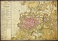
 Carte Strasbourg Meyers Konversationslexikon 1888.jpeg 2,634 × 1,760; 3.67 MB
-
 Gustave Fischbach-Strasbourg après le bombardement.jpg 1,024 × 743; 401 KB
-
 Karte Strassburg MK1888.png 2,634 × 1,760; 9.91 MB
-
 Meyers b15 s0371a.jpg 800 × 1,275; 334 KB
-
 Meyers b15 s0371b.jpg 800 × 546; 189 KB
-
 Meyers b6 s0189b.jpg 2,601 × 1,713; 4.7 MB
-
 Neudorf-plan-1895.jpg 13,038 × 10,556; 24.37 MB
-
 Plan de la ville, et citadelle de Strasbourg, avec leurs environs - btv1b102239544.jpg 11,461 × 8,017; 14.85 MB
-
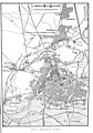
 Plan dr Stadt Strassburg nach amtlichen Quellen bearbeitet - btv1b10223967w.jpg 11,340 × 7,638; 13.85 MB
-
 Plan Strasbourg projet Conrath 1880.png 1,400 × 900; 2.08 MB
-
 Plan topographique de la Ville de Strasbourg divisée en quatre Cantons.jpg 6,652 × 5,421; 9.16 MB
-
 Plan-zur-Belagerung-von-Strassburg.jpg 10,439 × 7,622; 10.13 MB
-
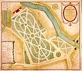 Strasbourg plan du parc du Contades XIXe siècle.jpg 1,566 × 1,359; 851 KB
-
 Vandernoot Plan de Strasbourg ce LV.25 mb.jpg 1,754 × 1,231; 495 KB
.jpg)
.jpg)
.jpg)


