Category:Maps of St. Clair County, Missouri
Jump to navigation
Jump to search
Counties of Missouri: Adair · Andrew · Atchison · Audrain · Barry · Barton · Bates · Benton · Bollingern · Boone · Buchanan · Butler · Caldwell · Callaway · Camden · Cape Girardeau · Carroll · Carter · Cass · Cedar · Chariton · Christian · Clark · Clay · Clinton · Cole · Cooper · Crawford · Dade · Dallas · Daviess · DeKalb · Dent · Douglas · Dunklin · Franklin · Gasconade · Gentry · Greene · Grundy · Harrison · Henry · Hickory · Holt · Howard · Howell · Iron · Jackson · Jasper · Jefferson · Johnson · Knox · Laclede · Lafayette · Lawrence · Lewis · Lincoln · Linn · Livingston · Macon · Madison · Maries · Marion · McDonald · Mercer · Miller · Mississippi · Moniteau · Monroe · Montgomery · Morgan · New Madrid · Newton · Nodaway · Oregon · Osage · Ozark · Pemiscot · Perry · Pettis · Phelps · Pike · Polk · Pulaski · Putnam · Ralls · Randolph · Ray · Reynolds · Ripley · Saline · Schuyler · Scotland · Scott · Shannon · Shelby · St. Charles · St. Clair · St. Francois · St. Louis · Ste. Genevieve · Stoddard · Stone · Sullivan · Taney · Texas · Vernon · Warren · Washington · Wayne · Webster · Worth · Wright · Independent citiy: St. Louis
Wikimedia category | |||||
| Upload media | |||||
| Instance of | |||||
|---|---|---|---|---|---|
| Category combines topics | |||||
| St. Clair County | |||||
county in Missouri, United States   | |||||
| Instance of | |||||
| Named after | |||||
| Location | Missouri | ||||
| Capital | |||||
| Inception |
| ||||
| Population |
| ||||
| Area |
| ||||
| Different from | |||||
| official website | |||||
 | |||||
Subcategories
This category has only the following subcategory.
Media in category "Maps of St. Clair County, Missouri"
The following 17 files are in this category, out of 17 total.
-
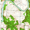 Corbin Iconium MO Quadrangle 1940 excerpt.jpg 1,011 × 1,019; 637 KB
-
 Corbin Iconium quad 1991 excerpt.png 734 × 673; 1.45 MB
-
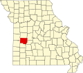 Map of Missouri highlighting Saint Clair County.svg 5,812 × 5,110; 112 KB
-
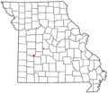
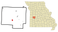
 Map of Missouri highlighting St. Clair County.png 300 × 263; 14 KB
-
 MOMap-doton-Collins.png 300 × 263; 13 KB
-
 MOMap-doton-Gerster.png 300 × 263; 13 KB
-
 MOMap-doton-Lowry City.png 300 × 263; 13 KB
-
 MOMap-doton-Osceola.png 300 × 263; 13 KB
-
 MOMap-doton-Roscoe.png 300 × 263; 13 KB
-
 MOMap-doton-Vista.png 300 × 263; 13 KB
-

-

-
-

-

-
-


