Category:Maps of Lynn, Massachusetts
Jump to navigation
Jump to search
Wikimedia category | |||||
| Upload media | |||||
| Instance of | |||||
|---|---|---|---|---|---|
| Category combines topics | |||||
| Lynn | |||||
city in Essex County, Massachusetts, United States     | |||||
| Instance of | |||||
| Part of |
| ||||
| Named after | |||||
| Location | Essex County, Massachusetts | ||||
| Head of government |
| ||||
| Inception |
| ||||
| Population |
| ||||
| Area |
| ||||
| Elevation above sea level |
| ||||
| official website | |||||
 | |||||
Subcategories
This category has the following 3 subcategories, out of 3 total.
Media in category "Maps of Lynn, Massachusetts"
The following 21 files are in this category, out of 21 total.
-
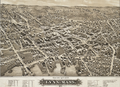 1879 Lynn Massachusetts by Bailey and Hazen BPL 10178.png 962 × 699; 1.42 MB
-

-
 Map and profile of Lynn grade crossing elimination.jpg 3,860 × 2,239; 1.03 MB
-
 1975 Lynn bus map.png 3,500 × 2,484; 15.46 MB
-
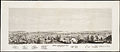
 Aero view of Lynn, Mass, 1916 - looking north (14966322891).jpg 2,000 × 1,300; 2.16 MB
-
 City of Lynn, Mass. (3369699017).jpg 2,000 × 1,902; 3.92 MB
-

-
 Lynn Historical Aerial.jpg 1,582 × 1,050; 403 KB
-
 Lynn ma highlight.png 788 × 466; 54 KB
-
 Lynn stations map.PNG 254 × 342; 213 KB
-
 Lynn Woods - handy guide for trampers (6094183378).jpg 1,871 × 2,000; 3.02 MB
-
 Lynn, Massachusetts, 1849.jpg 9,624 × 4,208; 24.65 MB
-
 Lynn-MA-neighborhood.png 240 × 220; 36 KB
-
 Map of Lynn and Saugus (2674579276).jpg 2,000 × 1,759; 2.52 MB
-
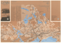
 Map of Lynn and Saugus - settled in 1629 LOC 2011589328.jpg 6,086 × 5,331; 4.05 MB
-
 Map of Lynn and Saugus - settled in 1629 LOC 2011589328.tif 6,086 × 5,331; 92.82 MB
-
 Map of the city of Lynn (9138252158).jpg 609 × 800; 136 KB
-
 Map of the city of Lynn Massachusetts (3886418663).jpg 2,000 × 1,547; 2.88 MB
-
 Plan of the city of Lynn Mass. from actual surveys (3720088313).jpg 1,024 × 797; 656 KB
-
 Race and ethnicity 2020 Lynn, MA.png 2,400 × 2,404; 2.82 MB
-
 Ten miles around Lynn (2675016436).jpg 1,455 × 2,000; 2.98 MB


.jpg)
.jpg)


.jpg)


.jpg)

.jpg)
.jpg)
.jpg)

.jpg)