Category:Maps of London by Braun & Hogenberg
Jump to navigation
Jump to search
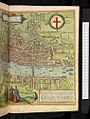
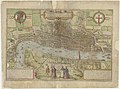
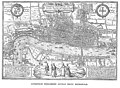
en:Joris Hoefnagel engraved many of the maps for Braun & Hogenburg's "Civitates Orbis Terrarum", from which this map is taken. The original is 19 x 12.75 inches. The inclusion of the steeple of St Paul's (destroyed in 1561) indicates that this map was taken from existing surveys.
Subcategories
This category has only the following subcategory.
M
Media in category "Maps of London by Braun & Hogenberg"
The following 21 files are in this category, out of 21 total.
-
 GMG433 14 London.jpg 6,926 × 4,904; 5.05 MB
-
 Braun London UBHD.jpg 2,133 × 1,495; 2.37 MB
-
 Londinum Feracissimi Angliae Regni Metropolis (BM G,2.3).jpg 2,500 × 1,739; 1.06 MB
-
 Cosmographie universelle 50057.jpg 3,927 × 2,683; 6 MB
-
 Antique map of London by Braun & Hogenberg.jpg 1,500 × 1,031; 549 KB
-
 Beschreibung der Städt der Welt - Braun & Hogenberg - btv1b52512111k (014 of 378).jpg 8,352 × 6,351; 8.84 MB
-
-

-
-
 Braun hogenberg I A m original.jpg 780 × 555; 173 KB
-
 Braun London HAAB.jpg 1,214 × 836; 1.04 MB
-
 Frans Hogenberg, Londinum (FL43890035 3793569).jpg 13,283 × 9,912; 191.14 MB
-
 Londinum Feracissimi Angliae Regni Metropolis (BM Heal,Topography.181).jpg 2,500 × 1,727; 977 KB
-
 Londinum feracissimi Angliae regni metropolis - btv1b53178904m (1 of 2).jpg 6,472 × 4,816; 5.12 MB
-
 Londinum Feracissimi Angliae Regni Metropolis - btv1b532253689 (2 of 3).jpg 5,775 × 4,126; 6.26 MB
-
 Londinum feracissimi Angliae regni metropolis - btv1b55004973q.jpg 7,687 × 5,999; 5.13 MB
-
 London Hoefnagel's Map of 1572.jpg 2,580 × 1,899; 1.95 MB
-
 Maps Of Old London Hoefnagel.jpg 2,602 × 1,901; 1.17 MB
-
 Stmartins 1562.jpg 281 × 205; 40 KB
-
 Civitates orbis terrarvm, liber primvs 1577 (107273421).jpg 15,566 × 11,001; 25.73 MB
-
 Репринт карты из "Атласа земного мира" Брауна и Хогенберга.jpg 600 × 450; 69 KB


.jpg)


.jpg)


.jpg)
.jpg)
.jpg)
.jpg)


.jpg)
