<nowiki>Category:Maps of Landkreis Ahrweiler; categoría de Wikimedia; kategori Wikimedia; Wikimedia category; د ويکيمېډيا وېشنيزه; Vikimedya kategorisi; ویکیمیڈیا زمرہ; kategória projektov Wikimedia; категорія проєкту Вікімедіа; 维基媒体分类; Wikimedia-Kategorie; kategorie na projektech Wikimedia; Wikimedia-Kategorie; विकिपीडिया:श्रेणी; page de catégorie de Wikimedia; kategorija na Wikimediji; विकिपीडिया वर्ग; категорија на Викимедији; Wikimedia-Kategorie; Wikimedia-kategori; kategori Wikimédia; تصنيف ويكيميديا; pajenn rummata eus Wikimedia; Wikimedia:ကဏ္ဍခွဲခြင်း; 維基媒體分類; Wikimedia категориясы; categoría de Wikimedia; Wikimedia-categorie; Wikimedia-Kategorie; tudalen categori Wikimedia; kategori e Wikimedias; Վիքիմեդիայի նախագծի կատեգորիա; 维基媒体分类; Wikimedia-kategori; ვიკიპედია:კატეგორიზაცია; ウィキメディアのカテゴリ; categoria Wikimedia; تصنيف بتاع ويكيميديا; විකිමීඩියා ප්රභේද පිටුව; categoria Vicimediorum; विकिमीडिया श्रेणी; Wikimedia-luokka; Wikimedia category; guruhi Vikimedia; катэгорыя ў праекце Вікімэдыя; Викимедиа проектындагы төркем; catigurìa di nu pruggettu Wikimedia; หน้าหมวดหมู่วิกิมีเดีย; Wikimedia:Kategorija; Wikimedia-Kategorie; Wikimedia:Klassys; категория на Уикимедия; categorie a unui proiect Wikimedia; categurìa 'e nu pruggette Wikimedia; Wikimedia-kategori; kawan Wikimèdia; 維基媒體分類; 위키미디어 분류; Wikimedia-bólkur; kategorio en Vikimedio; kategori Wikimedia; Wikimedia:Ronnaghys; উইকিমিডিয়া বিষয়শ্রেণী; kategori Wikimedia; 维基媒体分类; וויקימעדיע קאַטעגאָריע; kategorija w projektach Wikimedije; thể loại Wikimedia; Wikimedia projekta kategorija; Wikimedia-kategorie; categoria de um projeto da Wikimedia; 维基媒体分类; категорияд Ангилал; Wikimedia-kategori; kategori Wikimedia; پۆلی ویکیمیدیا; Wikimedia category; Vikimédia ñemohenda; Wikimédia-kategória; વિકિપીડિયા શ્રેણી; Wikimediako kategoria; категория в проекте Викимедиа; Wikimedia-Kategorie; катэгорыя ў праекце Вікімедыя; Wikimedia-kategorie; Wîkîmediya:Kategorî; विकिमिडिया श्रेणी; Wikimedia-Kategorie; קטגוריה במיזמי ויקימדיה; Викимедиа проектындагы төркем; 维基媒体分类; विकिमिडिया श्रेणी; jamii ya Wikimedia; Wikimedia-kategoriija; гурӯҳи Викимедиа; 維基媒體分類; categoría de Wikimedia; Wikimedia-categorie; categoria di un progetto Wikimedia; Wikimedia-categorie; Wikimedia category; 維基媒體分類; Wikimedia kategooria; Wikimedia-Kategorie; Wikimedia-kategory; kategorya ng Wikimedia; гурӯҳи Викимедиа; ẹ̀ka Wikimedia; Викимедиина категорија; categoria de um projeto da Wikimedia; kategorija na Wikimediji; ردهٔ ویکیپدیا; tumbung Wikimedia; kategoria ti Wikimedia; kategorija Wikimedie; Wikimedia proyektındağı törkem; Викимедиа категорияһы; categoria de Wikimedia; kategori Wikimedia; kategoria w projekcie Wikimedia; വിക്കിമീഡിയ വർഗ്ഗം; 維基媒體分類; kategori Wikimedia; விக்கிமீடியப் பகுப்பு; زمرو:وڪيپيڊيا زمرا بندي; Vikipidiya:Shopni; categoría de Wikimedia; Viciméid catagóir; κατηγορία εγχειρημάτων Wikimedia; Kategoriya ning Wikimedia</nowiki>
Subcategories
This category has only the following subcategory.


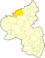 AW in Rheinland-Pfalz.svg 574 × 744; 133 KB
 Fronrath Ortskarte.png 6,692 × 9,491; 2.35 MB
 Gem kr aw adenau.png 1,500 × 1,264; 61 KB
 Gem kr aw altenahr.png 1,500 × 1,264; 61 KB
 Gem kr aw bneuenahr ahrw.png 1,500 × 1,264; 63 KB
 Gem kr aw brohltal.png 1,500 × 1,264; 68 KB
 Gem kr bad breisig.png 1,500 × 1,264; 68 KB
 Gem kr grafschaft.png 1,500 × 1,264; 63 KB
 Gem kr remagen.png 1,500 × 1,264; 63 KB
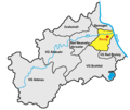 Gem kr sinzig.png 1,500 × 1,264; 60 KB
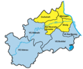 Kreis aw.png 1,500 × 1,264; 57 KB
 Lage des Landkreises Ahrweiler in Deutschland.PNG 197 × 235; 2 KB
 Locator map AW in Germany.svg 1,075 × 1,273; 513 KB
 Locator map AW in Rhineland-Palatinate.svg 708 × 913; 626 KB
 Wingsbachdrawing one layer.svg 693 × 952; 110 KB


