Category:Maps of Kurdufan (pre-2005)
Jump to navigation
Jump to search
English: Maps of the Kurdufan region in Sudan before 2005 — when state boundaries were changed.
- West Kordofan State was abolished in 2005 (according to Protocol of Comprehensive Peace Agreement), and divided between South Kurdufan State and North Kurdufan State.
Media in category "Maps of Kurdufan (pre-2005)"
The following 17 files are in this category, out of 17 total.
-
 Dschanub Kurdufan district map overview.svg 744 × 1,052; 72 KB
-
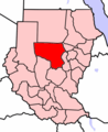
 Locator map Sudan North Kurdufan.png 480 × 568; 126 KB
-
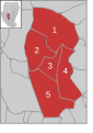
 Schamal Kurdufan Sudan map with districts.svg 744 × 1,052; 155 KB
-
 Schamal Kurdufan Sudan map with districts2.svg 744 × 1,052; 155 KB
-
 Schamal Kurdufan.PNG 491 × 600; 150 KB
-
 Sudan positionmap with districts Schamal Kurdufan.svg 725 × 933; 155 KB
-
 Dschanub Kurdufan Sudan map with districts.svg 744 × 1,052; 155 KB
-
 Dschanub Kurdufan Sudan map with districts2.svg 744 × 1,052; 155 KB
-
 Dschanub Kurdufan.PNG 491 × 600; 137 KB
-
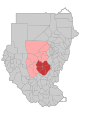
 Locator map Sudan South Kurdufan.png 480 × 568; 126 KB
-
 Sudan positionmap with districts Dschanub Kurdufan.svg 725 × 933; 155 KB
-
 Gharb Kurdufan district map overview.svg 744 × 1,052; 62 KB
-
 Gharb Kurdufan Sudan map with districts.svg 744 × 1,052; 155 KB
-
 Gharb Kurdufan Sudan map with districts2.svg 744 × 1,052; 155 KB
-
 Gharb Kurdufan.PNG 491 × 600; 150 KB
-
 Locator map Sudan West Kurdufan.png 480 × 568; 126 KB
-
 Sudan positionmap with districts Gharb Kurdufan.svg 725 × 933; 155 KB


