Category:Maps of Kosrae
Jump to navigation
Jump to search
English: Maps of Kosrae
日本語: コスラエ州の地図
Wikimedia category | |||||
| Upload media | |||||
| Instance of | |||||
|---|---|---|---|---|---|
| Category combines topics | |||||
| Kosrae | |||||
island in Federated States of Micronesia    | |||||
| Instance of | |||||
| Part of | |||||
| Location | Kosrae State, FM | ||||
| Located in or next to body of water | |||||
| Capital |
| ||||
| Head of government |
| ||||
| Population |
| ||||
| Area |
| ||||
| Elevation above sea level |
| ||||
| Different from | |||||
 | |||||
Media in category "Maps of Kosrae"
The following 22 files are in this category, out of 22 total.
-
 Kosrae (Karte).jpg 1,147 × 721; 143 KB
-
 Kosrae municipalities 1980.png 634 × 508; 946 KB
-
 Kosrae municipalities CDPs 1980.jpg 702 × 518; 88 KB
-
 Kosrae municipalities.jpg 4,424 × 3,296; 3.09 MB
-
 Kosrae saar.png 432 × 395; 50 KB
-
 Kosrae-map be.png 500 × 363; 28 KB
-
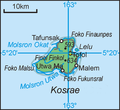
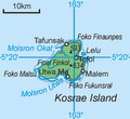 Kosrae.png 426 × 389; 33 KB
-
 Kusae - auf grundlage der brit. u. deutsch. seekarte LOC 2008621655.jpg 6,346 × 5,459; 5.09 MB
-
 Kusae - auf grundlage der brit. u. deutsch. seekarte LOC 2008621655.tif 6,346 × 5,459; 99.11 MB
-
 Kusaie (Kosrae).jpg 497 × 166; 63 KB
-
 Lelu Island.PNG 800 × 610; 854 KB
-
 Lelu mappa.GIF 366 × 266; 6 KB
-
 Lelu mk.GIF 366 × 266; 15 KB
-
 Malem mappa.GIF 366 × 266; 6 KB
-
 Malem mk.GIF 366 × 266; 15 KB
-
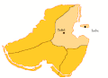
 Municipalities of Kosrae.GIF 366 × 266; 17 KB
-
 Sarfert Kusae Kosrae 1919.jpg 6,346 × 5,459; 9.99 MB
-
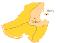
 Tafunsak mappa.GIF 366 × 266; 6 KB
-
 Tafunsak mk.GIF 366 × 266; 15 KB
-
 Txu-oclc-0607986778-kosrae.jpg 5,000 × 3,751; 3.02 MB
-
 Utwe mappa.GIF 366 × 266; 6 KB
-
 Utwe mk.GIF 366 × 266; 14 KB
.jpg)


.jpg)