Category:Maps of Kangchenjunga
Jump to navigation
Jump to search
Media in category "Maps of Kangchenjunga"
The following 24 files are in this category, out of 24 total.
-

-
 Darjeeling (Baedeker, 1914).jpg 2,134 × 1,591; 3.16 MB
-
 Detail, KANGCHENJUNGA MAP by JACOT-GUILLARMOD, 1914 (cropped).jpg 2,703 × 1,392; 706 KB
-
 Everest 1858.jpg 1,500 × 1,046; 228 KB
-
 GARWOOD MAP 640x617 148a.jpg 640 × 617; 109 KB
-
 Geology of Everest region, 1921.jpg 6,084 × 3,888; 5.51 MB
-

-
 Kangchenjunga 1955 trek.png 2,640 × 4,764; 29.61 MB
-
 Kangchenjunga 1955 trek.svg 2,475 × 4,467; 6.71 MB
-
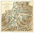
 KANGCHENJUNGA MAP by GARWOOD, 1903.jpg 2,256 × 2,136; 1.02 MB
-
 KANGCHENJUNGA MAP by JACOT-GUILLARMOD, 1914 (cropped).jpg 2,405 × 1,555; 727 KB
-
 KANGCHENJUNGA MAP by JACOT-GUILLARMOD, 1914.jpg 3,060 × 2,305; 1.06 MB
-
 Khangchendzonga np.jpg 5,213 × 6,562; 2.92 MB
-
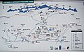 Map Goecha La Trek.JPG 3,313 × 2,081; 1.2 MB
-

-
 Pathibhara Map 3.jpg 4,928 × 3,264; 4.03 MB
-

-
 Round Kangchenjunga; a narrative of mountain travel and exploration (1903) (14771327254).jpg 2,856 × 2,756; 1.23 MB
-
 Sikhim and Bhutan - map.jpg 4,800 × 3,600; 10.23 MB
-
 Sikkim area map.svg 681 × 780; 212 KB
-
 Sikkimpolitical.png 354 × 534; 412 KB
-
 Sketch Map of the glaciers of Kangchenjunga by Edmund J. Garwood, 1903 (cropped).jpg 2,125 × 2,038; 1,008 KB
-
 Yalung Face of Kangchenjunga 1955.png 794 × 1,123; 1.06 MB
-
 Yalung Face of Kangchenjunga 1955.svg 744 × 1,052; 142 KB
.jpg)
.jpg)
.jpg)


_(cropped).jpg)


.jpg)


_(14587198197)_(cropped).jpg)

_(14587198197).jpg)
_(14771327254).jpg)


.jpg)

