Category:Maps of Fort Kochi
Jump to navigation
Jump to search
Wikimedia category | |||||
| Upload media | |||||
| Instance of | |||||
|---|---|---|---|---|---|
| Category combines topics | |||||
| Fort Kochi | |||||
neighborhood in Kochi, Ernakulam district, Kerala, India  | |||||
| Instance of | |||||
| Location | Kochi, Ernakulam district, Kerala, India | ||||
| Different from | |||||
 | |||||
Media in category "Maps of Fort Kochi"
The following 39 files are in this category, out of 39 total.
-
 06.10.2007 Portugiesisches Museum Kochi.jpg 1,672 × 1,161; 702 KB
-
 AMH-2509-NA Map of Caluetty and the shipyard east of Cochin.jpg 2,400 × 1,698; 558 KB
-
 AMH-2590-NA Representation of the siege of Cochin in 1663.jpg 2,400 × 1,140; 439 KB
-
 AMH-2591-NA Map of Cochin and part of the island of Vypin.jpg 2,400 × 1,696; 390 KB
-
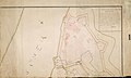
 AMH-2592-NA Map of Cochin and environs.jpg 2,400 × 1,720; 487 KB
-
 AMH-2593-NA Map of Cochin.jpg 2,400 × 1,701; 742 KB
-
 AMH-2594-NA Detailed drawings of woodwork used for the Cochin defences.jpg 2,400 × 1,727; 522 KB
-
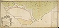 AMH-2595-NA Map of Cochin.jpg 2,400 × 1,160; 364 KB
-
 AMH-2596-NA Map of the city and the fort at Cochin.jpg 2,400 × 1,435; 436 KB
-
 AMH-2597-NA Map of Cochin.jpg 2,162 × 2,400; 471 KB
-
 AMH-2598-NA Map of Cochin.jpg 2,400 × 2,198; 907 KB
-
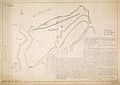
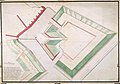
 AMH-2599-NA Map of the fortifications to the west and south of Cochin.jpg 2,400 × 1,784; 463 KB
-
 AMH-2600-NA Map of the fortifications to the west and south of Cochin.jpg 2,400 × 1,739; 504 KB
-
 AMH-2602-NA Map of the fortifications to the west and to the south of Cochin.jpg 2,400 × 1,681; 544 KB
-
 AMH-2603-NA Map of the fortifications at Cochin.jpg 2,400 × 1,330; 437 KB
-
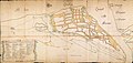
 AMH-2631-NA Map of the fort and the city of Cochin.jpg 2,400 × 1,628; 426 KB
-
 AMH-2632-NA Map of the fort and city of Cochin.jpg 2,400 × 1,667; 387 KB
-
 AMH-2633-NA Map of the fort at Cochin.jpg 2,400 × 1,539; 719 KB
-
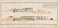
 AMH-2644-NA The Malabar coast.jpg 2,400 × 561; 287 KB
-
 AMH-3773-NA Map of Cochin and environs.jpg 2,400 × 1,860; 351 KB
-
 AMH-4483-NA Map of the city and fort at Cochin.jpg 2,400 × 1,667; 380 KB
-
 AMH-5352-NA Plans for changes to the fortifications at Cochin.jpg 2,400 × 1,728; 478 KB
-
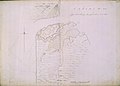
 AMH-5353-NA Map of Cochin and environs.jpg 1,852 × 2,400; 479 KB
-
 AMH-5354-NA Map of the fort and city of Cochin.jpg 2,400 × 1,991; 463 KB
-
 AMH-5356-NA Floor plan of the Cochin fort.jpg 2,400 × 1,560; 500 KB
-
 AMH-5357-NA Plans for alterations to the fortifications at Cochin.jpg 2,400 × 1,728; 410 KB
-
 AMH-5552-NA Plan for alterations to the fortifications at Cochin.jpg 2,400 × 1,835; 476 KB
-
 AMH-5553-NA Plan for alterations to the fortifications at Cochin.jpg 2,400 × 1,462; 389 KB
-
 AMH-5554-NA Plan for alterations to the fortifications at Cochin.jpg 2,400 × 1,135; 340 KB
-
 AMH-5555-NA Plan for alterations to the fortifications at Cochin.jpg 2,400 × 1,665; 497 KB
-
 AMH-6129-NA Map of Cochim, part B.jpg 2,284 × 2,400; 416 KB
-
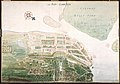 AMH-6148-NA Bird's eye view of the city of Cochin, India.jpg 2,400 × 1,682; 602 KB
-
 AMH-6149-NA Map of the city of Cochin.jpg 2,400 × 1,767; 474 KB
-
 AMH-6950-KB Cochin at the time of the conquest by Van Goens, 1663.jpg 2,400 × 1,931; 1.23 MB
-

-
 Fort Kochi City Map 1672.png 1,170 × 888; 1.61 MB
-
 Map of Portuguese Cochin.jpg 1,180 × 793; 711 KB
-
 Planta de cochim bocarro 1635.jpg 6,038 × 4,166; 6.68 MB
-


,_NG-20-F.jpg)


.jpg)