<nowiki>Category:Maps of Europa Island; categoría de Wikimedia; kategori Wikimedia; Wikimedia category; د ويکيمېډيا وېشنيزه; Vikimedya kategorisi; ویکیمیڈیا زمرہ; kategória projektov Wikimedia; категорія проєкту Вікімедіа; 维基媒体分类; Wikimedia-Kategorie; kategorie na projektech Wikimedia; kategorija na Wikimediji; विकिपीडिया:श्रेणी; page de catégorie de Wikimedia; kategorija na Wikimediji; विकिपीडिया वर्ग; категорија на Викимедији; Wikimedia-Kategorie; Wikimedia-kategori; kategori Wikimédia; تصنيف ويكيميديا; pajenn rummata eus Wikimedia; Wikimedia:ကဏ္ဍခွဲခြင်း; 維基媒體分類; Wikimedia категориясы; categoría de Wikimedia; Wikimedia-categorie; Викимедиа категорияһы; tudalen categori Wikimedia; Viciméid catagóir; ردهٔ ویکیپدیا; 维基媒体分类; Wikimedia-kategory; ვიკიპედია:კატეგორიზაცია; ウィキメディアのカテゴリ; categoria Wikimedia; تصنيف بتاع ويكيميديا; විකිමීඩියා ප්රභේද පිටුව; categoria Vicimediorum; विकिमीडिया श्रेणी; Wikimedia-luokka; Wikimedia category; guruhi Vikimedia; катэгорыя ў праекце Вікімэдыя; Викимедиа проектындагы төркем; catigurìa di nu pruggettu Wikimedia; หน้าหมวดหมู่วิกิมีเดีย; Wikimedia:Kategorija; Wikimedia-Kategorie; Wikimedia:Klassys; категория на Уикимедия; categorie a unui proiect Wikimedia; categurìa 'e nu pruggette Wikimedia; Wikimedia-kategori; kawan Wikimèdia; 維基媒體分類; 위키미디어 분류; Wikimedia-bólkur; kategorio en Vikimedio; kategori Wikimedia; Wikimedia:Ronnaghys; উইকিমিডিয়া বিষয়শ্রেণী; kategori Wikimedia; 维基媒体分类; וויקימעדיע קאַטעגאָריע; kategorija w projektach Wikimedije; thể loại Wikimedia; Wikimedia projekta kategorija; Wikimedia-kategorie; categoria de um projeto da Wikimedia; 维基媒体分类; категорияд Ангилал; Wikimedia-kategori; kategori Wikimedia; پۆلی ویکیمیدیا; Wikimedia category; Vikimédia ñemohenda; Wikimédia-kategória; વિકિપીડિયા શ્રેણી; Wikimediako kategoria; категория в проекте Викимедиа; Wikimedia-Kategorie; катэгорыя ў праекце Вікімедыя; Wikimedia-kategorie; Wîkîmediya:Kategorî; विकिमिडिया श्रेणी; Wikimedia-Kategorie; קטגוריה במיזמי ויקימדיה; Викимедиа проектындагы төркем; Wikimedia-Kategorie; विकिमिडिया श्रेणी; κατηγορία εγχειρημάτων Wikimedia; Wikimedia-kategoriija; гурӯҳи Викимедиа; kategoria w projekcie Wikimedia; categoría de Wikimedia; Wikimedia-categorie; categoria di un progetto Wikimedia; Wikimedia-categorie; Wikimedia category; 維基媒體分類; Wikimedia kategooria; Վիքիմեդիայի նախագծի կատեգորիա; Wikimedia-Kategorie; Wikimedia proyektındağı törkem; гурӯҳи Викимедиа; ẹ̀ka Wikimedia; Викимедиина категорија; categoria de um projeto da Wikimedia; Wikimedia-Kategorie; categoria de Wikimedia; tumbung Wikimedia; kategoria ti Wikimedia; kategorija Wikimedie; kategorya ng Wikimedia; Kategoriya ning Wikimedia; Vikipidiya:Shopni; kategori Wikimedia; jamii ya Wikimedia; വിക്കിമീഡിയ വർഗ്ഗം; 維基媒體分類; kategori Wikimedia; kategori e Wikimedias; زمرو:وڪيپيڊيا زمرا بندي; Wikimedia-kategori; categoría de Wikimedia; 維基媒體分類; 维基媒体分类; விக்கிமீடியப் பகுப்பு</nowiki>
Pages in category "Maps of Europa Island"
This category contains only the following page.


 Europa Island simplified land cover map-en.svg 1,750 × 1,300; 305 KB
 Europa Island simplified land cover map-fr.svg 1,750 × 1,300; 303 KB
 Europa Island simplified land cover map-mk.svg 1,750 × 1,300; 505 KB
 Europa Island-CIA WFB Map.png 331 × 356; 9 KB
 Europa Island.gif 331 × 356; 10 KB
 EuropaIsland Map-de.png 1,656 × 1,243; 254 KB
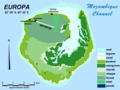 EuropaIsland Map-en.png 1,656 × 1,243; 224 KB
 EuropaIsland Map-fr.png 1,654 × 1,243; 255 KB
 EuropaIsland Map.png 1,697 × 1,243; 172 KB
 EuropaIsland-fr Map.png 1,682 × 1,243; 176 KB
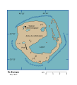 Ile Europa (french).svg 545 × 602; 103 KB
 Ile europa 76.jpg 948 × 442; 64 KB
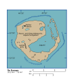 Ile Europa.svg 545 × 602; 106 KB
 LocationEuropa.png 250 × 119; 5 KB
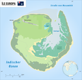 Reliefkarte Île Europa.png 2,500 × 2,419; 725 KB
 World Factbook (1990) Europa Island.jpg 559 × 511; 80 KB


.svg)


_Europa_Island.jpg)