Category:Maps of Dorsten
Jump to navigation
Jump to search
Wikimedia category | |||||
| Upload media | |||||
| Instance of | |||||
|---|---|---|---|---|---|
| Category combines topics | |||||
| Dorsten | |||||
town in Recklinghausen District, in North Rhine-Westphalia, Germany     | |||||
| Instance of |
| ||||
| Location | Recklinghausen, Münster Government Region, North Rhine-Westphalia, Germany | ||||
| Located in or next to body of water | |||||
| Head of government |
| ||||
| Has part(s) | |||||
| Significant event |
| ||||
| Population |
| ||||
| Area |
| ||||
| Elevation above sea level |
| ||||
| Different from | |||||
| official website | |||||
 | |||||
Media in category "Maps of Dorsten"
The following 20 files are in this category, out of 20 total.
-
 Befestigung Dorsten 17 Jh.jpg 1,000 × 1,350; 338 KB
-
 DB 15 railway map.png 1,405 × 1,054; 1.4 MB
-
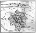 De merian Westphaliae 109.jpg 3,300 × 3,048; 2.65 MB
-
 Dorsten (Merian).jpg 3,300 × 3,048; 2.11 MB
-
 Dorsten 1633-cupper-engraving by matthaeus-merian.jpg 2,464 × 2,271; 4.01 MB
-
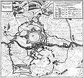 Dorsten belagerung 1641.jpg 2,467 × 2,281; 3.93 MB
-
 Dorsten in RE.svg 423 × 340; 1.39 MB
-
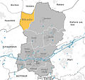
 Dorsten subdivisions.svg 2,061 × 1,934; 1.38 MB
-
 Dorsten-Rhade.jpg 639 × 600; 80 KB
-
 Erle 1400.jpg 3,264 × 2,448; 2.67 MB
-
 Herrlichkeit Lembeck Pries.jpg 2,342 × 1,863; 837 KB
-
 Lage der Stadt Dorsten in Deutschland.png 188 × 235; 5 KB
-
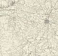
 Messtischblatt 4207 Raesfeld 1897.jpg 1,654 × 1,722; 885 KB
-
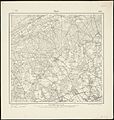
 Messtischblatt 4307 Dorsten 1894 Rechteck.jpg 7,318 × 7,054; 12.33 MB
-
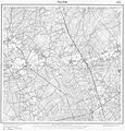
 Messtischblatt 4307 Dorsten 1894.jpg 8,247 × 8,702; 13.46 MB
-
 Messtischblatt 4308 Marl 1907.jpg 8,427 × 8,862; 14.37 MB
-
 Obervest Gliederung.jpg 11,549 × 8,401; 14.68 MB
-
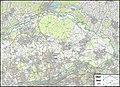
 Reichskarte 100 Dorsten.png 3,500 × 3,942; 32.95 MB
-
 Römer-Lippe-Route Dorsten 2016.png 874 × 533; 666 KB
-
 WandernKarte.jpg 557 × 630; 71 KB


.jpg)


