Category:Maps of County Clare
Jump to navigation
Jump to search
Wikimedia category | |||||
| Upload media | |||||
| Instance of | |||||
|---|---|---|---|---|---|
| Category combines topics | |||||
| County Clare | |||||
county in Ireland    | |||||
| Instance of | |||||
| Location |
| ||||
| Capital | |||||
| Legislative body |
| ||||
| Executive body |
| ||||
| Population |
| ||||
| Area |
| ||||
| official website | |||||
 | |||||
Subcategories
This category has only the following subcategory.
Media in category "Maps of County Clare"
The following 23 files are in this category, out of 23 total.
-
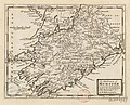
 The Counties of Clare and Limerick - By H. Moll Geographer - btv1b53056962m.jpg 3,624 × 2,704; 1.55 MB
-
-
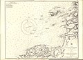 Admiralty Chart No 2442 Mutton Island Doonbeg Bay, Published 1856.jpg 11,249 × 8,187; 11.1 MB
-
 Baronies of Clare.jpg 3,142 × 2,227; 1.7 MB
-
 Clare (Dáil Éireann constituency).png 2,294 × 2,910; 69 KB
-
 Clare - British Isles.svg 1,250 × 1,835; 1,002 KB
-
 Clare Ireland (BI Sect 7).svg 583 × 711; 1,004 KB
-
 ClareEire.PNG 500 × 586; 17 KB
-
 Claremapover85.jpg 1,936 × 1,303; 435 KB
-
 County Clare in Irish.jpg 1,283 × 809; 281 KB
-
 Ireland map County Clare Magnified.png 188 × 244; 10 KB
-
 IrelandClare.png 200 × 249; 30 KB
-
 Kingdom of Thomond.png 1,655 × 955; 137 KB
-
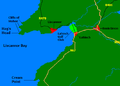 Liscannor Bay-D.PNG 533 × 383; 15 KB
-
 Liscannor-Bay.PNG 415 × 541; 12 KB
-
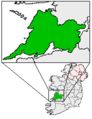
 Location map Ireland County Clare.png 1,368 × 845; 749 KB
-
 Map clare 1842.jpg 850 × 1,100; 612 KB
-
 Map Noughaval and Ballyganner North by Thomas Johnson Westropp 1897.png 2,975 × 1,281; 67 KB
-
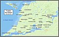
 Map of Ennis.png 1,360 × 896; 641 KB
-
 Parishes of County Clare.png 1,330 × 826; 73 KB
-

-
 Poor Law Unions of County Clare.png 1,356 × 842; 85 KB
-
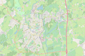
 Spanish Point street map.jpg 1,394 × 1,152; 76 KB


.png)

.svg)


.jpg)

