Category:Maps of Bruges by Braun & Hogenberg
Jump to navigation
Jump to search
Media in category "Maps of Bruges by Braun & Hogenberg"
The following 15 files are in this category, out of 15 total.
-
 Brugge.stadsplan 17de eeuw.JPG 2,277 × 1,561; 1.6 MB
-
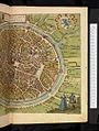
 Beschreibung der Städt der Welt - Braun & Hogenberg - btv1b52512111k (062 of 378).jpg 8,249 × 6,342; 8.11 MB
-
-

-
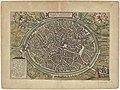
 Braun Brugge UBHD.jpg 2,032 × 1,433; 2.08 MB
-
 Brugae Flandricarum urbium ornamenta.jpg 7,724 × 5,984; 10.52 MB
-
 Brugae, Flandricarum urbium ornamenta - btv1b531789124 (1 of 2).jpg 6,506 × 4,898; 4.99 MB
-
 Brugae, Flandricarum urbium ornamenta.jpg 2,560 × 1,920; 1.72 MB
-
 Bruges by Braun and Hogenberg, print from 1635.jpg 3,500 × 2,450; 3.05 MB
-
 Brugae Flandricarum Urbium Ornamenta.jpg 1,202 × 819; 1.02 MB
-
 Frans Hogenberg, Brugae (FL43890129 3940552).jpg 13,283 × 9,912; 191.78 MB
-
 Map of Bruges by Braun and Hogenberg.jpg 3,379 × 2,711; 1.81 MB
-
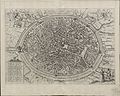
 Old map of Bruges by Braun & Hogenberg.jpg 2,875 × 1,999; 1.42 MB
-
 Stedenboeken van de wereld by Johannes Janssonius 1657 ; page 77.jpg 10,622 × 7,930; 20.36 MB
-
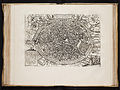
 Civitates orbis terrarvm, liber primvs 1577 (107273944).jpg 15,874 × 10,955; 26.4 MB

.jpg)


.jpg)


.jpg)


.jpg)