Category:Maps of Boston Harbor
Jump to navigation
Jump to search
Wikimedia category | |||||
| Upload media | |||||
| Instance of | |||||
|---|---|---|---|---|---|
| Category combines topics | |||||
| Boston Harbor | |||||
estuary and harbor of Massachusetts Bay in the northeastern United States .jpg) | |||||
| Instance of | |||||
| Part of | |||||
| Location | Massachusetts | ||||
| Inflows | |||||
 | |||||
Subcategories
This category has the following 2 subcategories, out of 2 total.
Media in category "Maps of Boston Harbor"
The following 35 files are in this category, out of 35 total.
-

-

-

-

-
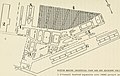
 31 of 'King's Handbook of Boston Harbor ... With ... illustrations' (11153202495).jpg 2,154 × 1,408; 331 KB
-
 86 of 'Cassell's History of the United States ... Illustrated' (11251251543).jpg 1,106 × 1,186; 376 KB
-

-
 A new suruey of the harbour of Boston in New England (2675705726).jpg 2,000 × 1,673; 2.91 MB
-

-

-
 Admiralty Chart No 1516 Boston Harbour, Published 1962.jpg 18,433 × 11,255; 66.97 MB
-
 Admiralty Chart No 2482 Fletchers Neck to Cape Cod, Published 1866.jpg 8,208 × 12,001; 9.15 MB
-
 Alewife Reservation and Alewife Brook master plan (2003) (17950191821).jpg 2,634 × 3,864; 3.88 MB
-

-

-

-
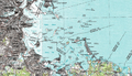
 Boston Bay and Harbor (9136152641).jpg 794 × 800; 111 KB
-
 Boston Harbor World War II naval installations.pdf 347 × 458; 52 KB
-
 Boston Harbor, Nachant Bay, Nantasket Road, Broad Sound, &c. (2675709026).jpg 2,000 × 1,473; 1.79 MB
-
 Boston Harbour (2674920749).jpg 2,000 × 1,527; 1.83 MB
-

-
-

-
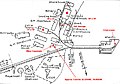
 Boston-Mines-1945.jpg 892 × 632; 137 KB
-
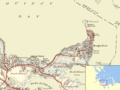
 Bostonharbourtopomap.png 1,278 × 732; 2.19 MB
-
 BostonNeck.jpg 600 × 616; 408 KB
-
 Callahan Tunnel.png 1,138 × 998; 319 KB
-
 Charlesrivermap.png 1,000 × 1,000; 587 KB
-
 Hingham Bay Massachusetts.svg 1,600 × 1,174; 1.37 MB
-
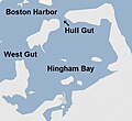 Hull Gut Map.jpg 566 × 521; 45 KB
-
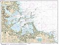 NPS boston-harbor-islands-chart.jpg 5,472 × 4,208; 5.16 MB
-
 Nut Island MA 1946.png 1,304 × 978; 1.16 MB
-
 Situationsplan von Boston (Massachusetts).jpg 727 × 459; 97 KB
-
 Sketch of Boston Harbor and Bay (3120960458).jpg 2,000 × 1,702; 2.99 MB
-
 Strong-Mine-Handling.jpg 662 × 464; 64 KB


.jpg)
.jpg)
.jpg)
.jpg)
.jpg)


_(17950191821).jpg)
.jpg)
_under_title_i_of_the_grant_and_loan_for_public_works_and_development_facilities_program_(catalog_no._11.300)_for_rehabilitation_of_the_(19746103305).jpg)
.jpg)
.jpg)
.jpg)

.jpg)
.jpg)


.jpg)
.jpg)
