Category:Maps of Bajamont
Jump to navigation
Jump to search
Wikimedia category | |||||
| Upload media | |||||
| Instance of | |||||
|---|---|---|---|---|---|
| Category combines topics | |||||
| Bajamont | |||||
commune in Lot-et-Garonne, France _ancienne_mairie.jpg) .svg)  | |||||
| Instance of | |||||
| Location |
| ||||
| Population |
| ||||
| Area |
| ||||
| Elevation above sea level |
| ||||
| official website | |||||
 | |||||
Media in category "Maps of Bajamont"
The following 5 files are in this category, out of 5 total.
-
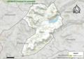
 47019-Bajamont-argile.jpg 3,057 × 2,480; 523 KB
-
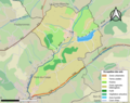 47019-Bajamont-Sols.png 3,270 × 2,598; 2.3 MB
-
 47019-Bajamont-ZNIEFF1.png 5,866 × 4,133; 10.42 MB
-
 47019-Bajamont-ZNIEFF2.png 5,866 × 4,133; 10.45 MB
-
 Map commune FR insee code 47019.png 756 × 605; 47 KB


