Category:Maps of Avranches
Jump to navigation
Jump to search
Wikimedia category | |||||
| Upload media | |||||
| Instance of | |||||
|---|---|---|---|---|---|
| Category combines topics | |||||
| Avranches | |||||
commune in Manche, France  .svg)  | |||||
| Instance of |
| ||||
| Location |
| ||||
| Head of government |
| ||||
| Legal form |
| ||||
| Inception |
| ||||
| Population |
| ||||
| Area |
| ||||
| Replaces |
| ||||
| official website | |||||
 | |||||
Media in category "Maps of Avranches"
The following 18 files are in this category, out of 18 total.
-
 50 MANCHE carte grille communale densite INSEE.png 3,507 × 2,480; 2.53 MB
-
 50-AAV2020-Avranches.png 3,519 × 2,930; 1.9 MB
-
 50-Avranches-AAV2020.png 3,519 × 2,930; 1.27 MB
-
 50025-Avranches-Hydro.jpeg 5,846 × 4,133; 2.98 MB
-
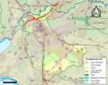 50025-Avranches-Sols.png 3,270 × 2,598; 3.85 MB
-
 50616-Le Val-Saint-Père-Sols.png 3,270 × 2,598; 3.34 MB
-
 Arrondissement d Avranches.PNG 579 × 478; 15 KB
-
 Avranches - Plan du XVIIIe siècle.svg 2,925 × 2,355; 29 KB
-
 Avranches OSM 01.png 588 × 576; 208 KB
-
 Avranches OSM 02.png 588 × 576; 356 KB
-
 Carte Avranches (commune nouvelle).png 514 × 506; 404 KB
-
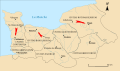
 Cartepbmsm.gif 611 × 549; 54 KB
-
 Diocèse Avranches 1789.svg 2,000 × 1,922; 801 KB
-
 District d'Avranches, 1792.jpg 1,279 × 1,398; 866 KB
-
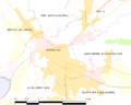 Map commune FR insee code 50025.png 756 × 605; 35 KB
-
 Normandie - Bas-Empire romain - Cités et capitales des cités-es.svg 3,532 × 2,104; 651 KB
-
 Normandie - Bas-Empire romain - Cités et capitales des cités.svg 3,532 × 2,104; 287 KB
-
 Normandie - Haut-Empire romain - Cités et capitales des cités.svg 3,532 × 2,104; 297 KB


.png)


