Category:Maps of Aurelian Walls (Rome)
Jump to navigation
Jump to search

Media in category "Maps of Aurelian Walls (Rome)"
The following 15 files are in this category, out of 15 total.
-
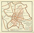
 Plan of Rome in the Middle Ages - Historical Atlas by William R. Shepherd, 1923.jpg 1,016 × 1,063; 498 KB
-
 Karte Rom unter Augustus MKL1888-Gates.JPG 713 × 549; 166 KB
-
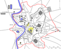 Muraurelien planrome.png 1,128 × 900; 83 KB
-
 Plan Rome- Aureliaanse Muur.png 1,128 × 900; 249 KB
-
 Platner - Ancient Rome city growth.jpg 750 × 729; 134 KB
-
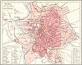 Roma Plan.jpg 1,840 × 1,463; 2.5 MB
-
 Roma PlanFXD.jpg 1,840 × 1,463; 1.06 MB
-
 Topography and Monuments of Ancient Rome (Menke).jpg 2,268 × 1,559; 1 MB
-
 Walls of Rome 6th century.png 1,200 × 853; 174 KB
-
 Aureliaplan.jpg 656 × 445; 80 KB
-
 Map of ancient Rome sr.svg 1,481 × 1,424; 40 KB
-
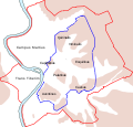 Map of ancient Rome.svg 1,481 × 1,424; 40 KB
-
 Muraurelien planrome2.png 1,814 × 1,361; 591 KB
-
 Walls of Rome 6th century (cropped).png 1,157 × 819; 215 KB
-
 Geschichte Roms und der Papste im Mittelalter 1898 (143025940).jpg 3,024 × 4,348; 10.81 MB


.jpg)


.png)
.jpg)