Category:Maps of Arvillard
Jump to navigation
Jump to search
Wikimedia category | |||||
| Upload media | |||||
| Instance of | |||||
|---|---|---|---|---|---|
| Category combines topics | |||||
| Arvillard | |||||
commune in Savoie, France    | |||||
| Instance of | |||||
| Location |
| ||||
| Population |
| ||||
| Area |
| ||||
| Different from | |||||
| official website | |||||
 | |||||
Subcategories
This category has only the following subcategory.
G
- Geological maps of Arvillard (5 F)
Media in category "Maps of Arvillard"
The following 12 files are in this category, out of 12 total.
-
 73021-Arvillard - Localisation.png 3,507 × 2,480; 1.1 MB
-
 73021-Arvillard-Cadastre.png 7,015 × 4,960; 8.03 MB
-
 73021-Arvillard-Hydro.jpeg 5,846 × 4,133; 3.01 MB
-
 73021-Arvillard-Hydro.png 7,015 × 4,960; 5.37 MB
-
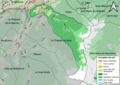
 73021-Arvillard-Natura 2000.png 7,015 × 4,960; 4.51 MB
-
 73021-Arvillard-Orthophoto.png 7,015 × 4,960; 27.96 MB
-
 73021-Arvillard-Sols.png 7,015 × 4,960; 5.87 MB
-
 73021-Arvillard-ZNIEFF1.png 7,015 × 4,960; 5.08 MB
-
 73021-Arvillard-ZNIEFF2.png 7,015 × 4,960; 4.83 MB
-
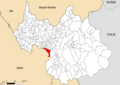
 Map commune FR insee code 73021.png 756 × 605; 85 KB
-
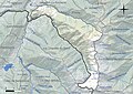
 Plan commune.jpg 799 × 983; 91 KB
-
 Plan commune.png 1,187 × 1,461; 377 KB


