Category:Maps of Abyssinia by Mercator-Hondius
Jump to navigation
Jump to search
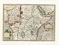
English: Hondius' Abissinorum sive pretiosi Joannis imperium was published in the Mercator-Hondius editions since the 1600s. Its main feature is the "Ethiopian Empire" which is supposedly heir to the mythical "Prester John" (alluded to in the title) and stretches all across Central Africa and includes locations connected to the Queen of Sheba, the Amazons, etc. Huge inland lakes are featured (Niger Lacus, Zaire Lacus, Zembre Lacus, Zanan Lacus) of which Zaire+Zembre Lacus would resemble Lake Tanganijka but transposed thousands of kilometers to the southwest, together with the sources of the much elongated Nile. The cartographer responsible combined travel reports from the region with a lot of speculation, to fill up the map.
The coastlines are more connected to the known realities of the time, including Nubia to Abyssinia's North, the Red Sea and the Eastern African coasts. A side-map shows the Kingdom of the Kongo, which is located about the place of real Angola (which is also labeled there). The map was reprinted for about a hundred years.
Media in category "Maps of Abyssinia by Mercator-Hondius"
The following 25 files are in this category, out of 25 total.
-
 Abissinorum sive pretiosi Joannis imperium - btv1b8595312k (1 of 2).jpg 8,098 × 5,881; 9 MB
-
 Abissinorum sive Pretiosi Joannis Imperiu. Scala Milliarum Germanicor - btv1b8459541w.jpg 4,654 × 6,164; 3.78 MB
-
 Abissinorum sive Pretiosi Joannis Imperiu. Scala Milliarum Germanicor - btv1b84595429.jpg 4,560 × 5,767; 3.94 MB
-

-
 Atlas Minor Gerardi Mercatoris 1609 (106757628).jpg 5,944 × 4,690; 5.81 MB
-
 Atlas Minor Gerardi Mercatoris 1609 (106757642).jpg 5,989 × 4,673; 5.56 MB
-
 Cosmographicae (10534327).jpg 12,033 × 8,154; 29.77 MB
-

-

-
 Abissinorum Sive Pretiosi Joannis Imperiu.jpg 12,375 × 8,872; 28.5 MB
-

-

-

-
 GMercator AbissinorumImperium.jpg 12,935 × 9,837; 25.54 MB
-
 GMercator AbissinorumImperium.png 1,042 × 790; 1.57 MB
-
 Mercator Congo map.jpg 879 × 874; 563 KB
-
 Abissinorum Sive.jpg 5,119 × 3,874; 7.91 MB
-

-

-
 Atlas ou Representation du Monde Universel t. 2. 1633 (110102888).jpg 17,096 × 12,060; 33.64 MB
-
 GMercator AbissinorumImperium copy2.jpg 4,657 × 3,169; 12.5 MB
-

-
 Abissinorum sive Pretiosi Joannis imperium - btv1b85953115 (1 of 2).jpg 7,936 × 7,019; 10.08 MB
-
 Kingdom of the Congo in a cartouche, by Gerardus Mercator.jpg 2,800 × 2,895; 1.86 MB
-
 GMercator AbissinorumImperium back.jpg 13,319 × 10,091; 26.46 MB
.jpg)


.jpg)
.jpg)
.jpg)
.jpg)
_-_btv1b53096740c_(498_of_603).jpg)
.jpg)

.jpg)
.jpg)
.jpg)


.jpg)

.jpg)

.jpg)
.jpg)


.jpg)