Category:Maps of 20th-century Arabia
Jump to navigation
Jump to search

English: Category for maps showing the history of the Arabian Peninsula in the 20th century AD (roughly AH 1317-AH 1420).
Old maps belong into: Category:20th-century maps of Arabia or its subcategories.
The modern states of Arabia were founded in the 20th century, so maps specifically about the history of some of these states, should be sorted in the history categories of those.
Old maps belong into: Category:20th-century maps of Arabia or its subcategories.
The modern states of Arabia were founded in the 20th century, so maps specifically about the history of some of these states, should be sorted in the history categories of those.
Subcategories
This category has the following 3 subcategories, out of 3 total.
1
M
- Maps of the Kingdom of Hejaz (10 F)
Media in category "Maps of 20th-century Arabia"
The following 25 files are in this category, out of 25 total.
-
 01 Southern Arabia Map.tif 2,953 × 2,142; 6.05 MB
-
 Arabistan 1907.png 651 × 565; 144 KB
-
 Sa mapa7.png 228 × 288; 12 KB
-
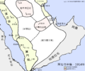
 Arabia 1914 (zh-hans).png 887 × 747; 374 KB
-
 Arabia 1914 (zh-hant).png 887 × 747; 332 KB
-
 Arabia 1914-ar.png 976 × 821; 164 KB
-
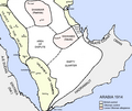 Arabia 1914.png 976 × 821; 111 KB
-
 Arabia ar.png 976 × 821; 152 KB
-
 Map of Arabian peninsula in 1918.jpg 1,080 × 1,491; 98 KB
-
 Arabia1919.jpg 900 × 925; 127 KB
-
 Sa mapa8.png 228 × 288; 14 KB
-
 Arabistan 1925.png 1,024 × 1,047; 315 KB
-
 1930'larda Ortadoğu.png 1,000 × 1,000; 1.59 MB
-
 Al Ayed Emirate of Asir-ar.jpg 640 × 658; 107 KB
-
 Al Ayed Emirate of Asir.jpg 640 × 658; 66 KB
-
 Arabia 1914-es.svg 2,382 × 2,000; 330 KB
-
 Arabia Armistice Mudros.png 3,242 × 3,572; 1.12 MB
-
 Hejaz Vilayet.png 366 × 357; 48 KB
-
 Hejaz Yemen Nejd Map.jpg 567 × 602; 57 KB
-
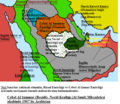
 Map of the kingdom of Hejaz and Nejd.png 1,135 × 961; 69 KB
-
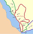
 Map of the Sultanate of Nejd.png 1,174 × 991; 75 KB
-
 SA Map.png 1,899 × 1,641; 327 KB
-
 Sa mapa6.png 228 × 288; 14 KB
-
 Shisr map.jpg 950 × 814; 70 KB
-
 خريطة لمشيخة ال شعلان من الرولة تحت حكم النوري الشعلان.jpg 1,038 × 808; 89 KB


.png)
.png)


