Category:Maps of 11th-century Montenegro
Jump to navigation
Jump to search
Countries of Europe: Bulgaria · France‡ · Germany · Greece · Italy · Montenegro · Poland · Portugal‡ · Serbia · Spain‡
‡: partly located in Europe
‡: partly located in Europe
| Preceded by: ' |
Maps of 11th-century Montenegro 1001 AD-1100 AD |
Succeeded by: Maps of 12th-century Montenegro |
Subcategories
This category has only the following subcategory.
S
Media in category "Maps of 11th-century Montenegro"
The following 26 files are in this category, out of 26 total.
-
 A1 Kingdom of Duklja and Byzantine Empire1081 c AD.JPG 1,077 × 681; 124 KB
-
 Bodin's Serbia, map by Stanoje Stanojević.jpg 619 × 599; 69 KB
-
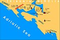
 Boka Kotorska zupe u srednjem vijeku.jpg 999 × 678; 215 KB
-
 Bulgaria Samuil (997-1014)cs.png 2,000 × 1,632; 413 KB
-
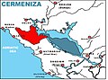 Cermeniza distr. XI c AD.jpg 1,077 × 799; 145 KB
-
 Cupelnich distr. XI c AD.jpg 1,077 × 799; 158 KB
-
 Dio granice Duklje kralja Mihajla Vojislavljevica.png 567 × 570; 105 KB
-
 Dracevica zupa.jpg 999 × 678; 215 KB
-
 Gorsca-distr.---XI-c-AD.jpg 1,077 × 799; 150 KB
-
 JEZERSKE ZUPE XI-c-AD.JPG 1,140 × 606; 155 KB
-
 Kraljevina Duklja za vrijeme Bodina.gif 1,235 × 1,145; 455 KB
-
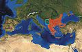
 L'impero bizantino nel 1045.jpg 800 × 554; 351 KB
-
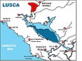 Lusca distr. XI-c-AD.jpg 1,077 × 799; 141 KB
-
 Prapratna XI c.png 1,234 × 1,553; 204 KB
-
 PRINCIPALITY 1050.jpg 878 × 931; 155 KB
-
 Principality Duklja (Doclea) half XI century-pt.svg 2,494 × 1,351; 31 KB
-
 Principality Duklja (Doclea) half XI century.svg 2,494 × 1,351; 34 KB
-
 Rajmond IV Tuluski u Duklji sr cir.svg 626 × 441; 234 KB
-
 Rajmond IV Tuluski u Duklji sr lat.svg 626 × 441; 222 KB
-
 Rajmond IV Tuluski u Duklji-pt.svg 626 × 441; 68 KB
-
 Serbian lands in 1050 pl.png 442 × 377; 104 KB
-
 Srbsko XI pt.svg 420 × 350; 240 KB
-
 Suacium XI c AD.jpg 705 × 591; 65 KB
-
 Zeta Doclea and Raymond IV de Toulouse-es.svg 2,819 × 1,974; 146 KB
-
 Zeta Doclea and Raymond IV de Toulouse.svg 626 × 441; 225 KB
-
 Србија у време Стефана Војислава.png 1,400 × 1,175; 306 KB


cs.png)


_half_XI_century-pt.svg)
_half_XI_century.svg)


