Category:Maps of Świnoujście
Jump to navigation
Jump to search
Wikimedia category | |||||
| Upload media | |||||
| Instance of | |||||
|---|---|---|---|---|---|
| Category combines topics | |||||
| Świnoujście | |||||
city with powiat rights in West Pomeranian Voivodeship, Poland      | |||||
| Instance of |
| ||||
| Location | |||||
| Inception |
| ||||
| Population |
| ||||
| Area |
| ||||
| Elevation above sea level |
| ||||
| official website | |||||
 | |||||
Media in category "Maps of Świnoujście"
The following 22 files are in this category, out of 22 total.
-
 800px-Wolin mapa Swinoujsci.png 1,088 × 784; 172 KB
-
 Karte der Bahnstrecke Wolgast–Heringsdorf–Ducherow.png 1,769 × 1,381; 638 KB
-
 Karte Insel Usedom (Swinemünde).png 810 × 503; 272 KB
-
 Karte Insel Usedom.png 1,153 × 1,057; 458 KB
-
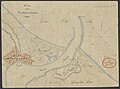 Karte von Swinemünde 1834.jpg 3,382 × 2,514; 6.07 MB
-
 Kolej-Świnoujście.png 2,617 × 1,547; 424 KB
-
 La2-demis-usedom.png 654 × 765; 27 KB
-
 Meyer‘s Zeitungsatlas 031 – Provinz Pommern.jpg 7,344 × 6,224; 17.16 MB
-
 POL Świnoujście map.svg 497 × 463; 47 KB
-
 Swinemünde und Umgebung.jpg 2,165 × 1,380; 2.73 MB
-
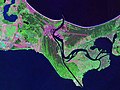 Swinoujscie Landsat.jpeg 800 × 600; 104 KB
-
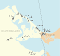
 Swinoujscie location map.png 1,182 × 1,095; 429 KB
-
 Swinoujscie Mapa.PNG 580 × 425; 54 KB
-
 Swinoujscie Powiat Grodzki.png 405 × 431; 10 KB
-
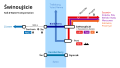 Swinoujscie Rail and Water Transportation Map.svg 1,280 × 720; 17 KB
-
 Swinoujscie rail water map.png 1,583 × 895; 83 KB
-
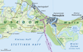
 Usedom Karte Map Heringsdorf Ahlbeck Bansin Swinemünde.png 755 × 620; 323 KB
-
 Usedom Karte.svg 1,178 × 1,104; 299 KB
-
 Usedom UBB.JPG 872 × 546; 80 KB
-
 Bundesarchiv Bild 196-02051, Swinemünde.jpg 795 × 800; 61 KB
-
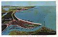
 Usedom Postkarte 004.jpg 2,048 × 1,299; 461 KB
-
 Zalew Szczecinski administrative map.png 704 × 742; 149 KB

.png)


