Category:Maps in Cosmographia (Münster)
Jump to navigation
Jump to search
Subcategories
This category has the following 3 subcategories, out of 3 total.
Media in category "Maps in Cosmographia (Münster)"
The following 200 files are in this category, out of 233 total.
(previous page) (next page)-
-

-
 Affricque - btv1b8595135w.jpg 4,658 × 3,479; 2.58 MB
-
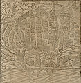 Calarisarquer.jpg 1,586 × 1,632; 1.37 MB
-
 Claudius Ptolemaeus - Geographia universalis.jpg 1,416 × 1,042; 1.23 MB
-
 Closeup of South Asia 1560.jpg 800 × 602; 148 KB
-
 Colmar, Alsace (1628).jpg 800 × 594; 163 KB
-
 Cosmographia Bodensee koloriert.jpg 629 × 475; 307 KB
-
 Dacia, 1620 (Münster).jpg 2,348 × 1,862; 857 KB
-
 David Kandel 1569.jpg 3,648 × 2,736; 1.89 MB
-
 De Regno et tota regione Poloniae Cosmographia Universalis.png 2,337 × 3,805; 3.12 MB
-
 De Regno et tota regione Poloniae, S. Münster, Cosmographia universalis.png 1,845 × 1,465; 1.3 MB
-
 Deutschlandkarte aus der Ausgabe der Cosmographia von 1538.jpg 1,543 × 1,325; 962 KB
-
 Die Neuwen Inseln so hinder Hispanica gegen Orient bey dem Landt Indie ligen. NYPL434937.tiff 5,595 × 4,880; 78.12 MB
-
 Europa Prima Nova Tabula - no-nb krt 00485.jpg 4,576 × 3,584; 5.39 MB
-
 Tabula Europae I (1552).jpg 1,567 × 1,200; 2.05 MB
-
 Tabula Europae VII.jpg 556 × 450; 65 KB
-
 Europe as a Queen by Sebastian Münster.jpg 2,025 × 3,294; 2.47 MB
-
 Europe As A Queen Sebastian Munster 1570.jpg 924 × 1,450; 1.27 MB
-
 Europe shaped into a queen* (1628).jpg 800 × 1,067; 188 KB
-
 Famagusta, Cyprus (1600).jpg 800 × 600; 164 KB
-
 Florence 1600.jpg 800 × 600; 168 KB
-
 Florence a close view 1600.jpg 800 × 600; 184 KB
-
 Florence A detailed view 1600.jpg 800 × 600; 171 KB
-
 Frankfurt a closer view 1600.jpg 800 × 600; 160 KB
-
 Frankfurt detail 11600.jpg 800 × 600; 153 KB
-
 Frankfurt detail 2 1600.jpg 800 × 600; 152 KB
-
 Free Imperial City of Speyer, 1588.jpg 874 × 389; 127 KB
-
 Freiburg 1600 left.jpg 800 × 600; 139 KB
-
 Freiburg 1600 right.jpg 800 × 600; 152 KB
-
 Freilingen 1574.jpg 1,227 × 1,008; 377 KB
-
 Freising 1600 a coloser view.jpg 800 × 600; 150 KB
-
 Freising detail 1600.jpg 800 × 600; 138 KB
-
 Friebourg, Switzerland (1600) center.jpg 800 × 600; 160 KB
-
 Friebourg, Switzerland (1600) left.jpg 800 × 600; 155 KB
-
 Friebourg, Switzerland (1600) right.jpg 800 × 600; 149 KB
-
 Fulda 1 1600.jpg 800 × 600; 155 KB
-
 Fulda 2 1600.jpg 800 × 600; 144 KB
-
 Fulda 3 1600.jpg 800 × 600; 155 KB
-
 Genf, Switzerland (1600) center.jpg 800 × 600; 154 KB
-
 Genf, Switzerland (1600) left.jpg 800 × 600; 157 KB
-
 Genf, Switzerland (1600) right.jpg 800 × 600; 137 KB
-
 Genoa in detail1 1600.jpg 800 × 600; 157 KB
-
 Genoa in detail2 1600.jpg 800 × 600; 168 KB
-
 Genoa in detail3 1600.jpg 800 × 600; 158 KB
-

-

-
 Gotha a closer view 1600.jpg 800 × 600; 154 KB
-
 Groningen 1600.jpg 800 × 600; 154 KB
-
 Gyula, Hungary, under attack (1600).jpg 800 × 600; 163 KB
-
 Haarlem (1600) a closer view.jpg 800 × 600; 177 KB
-
 Hamburg 1600.jpg 800 × 600; 141 KB
-
 Hammelburg 1600.jpg 800 × 600; 160 KB
-
 Hertogenbosch, Holland overview (1600) a closer view.jpg 800 × 600; 176 KB
-
 India Extrema XIX Nova Tabula.jpg 500 × 400; 56 KB
-
 Ingelheim 1600.jpg 800 × 600; 166 KB
-
 Map of America by Sebastian Munster.JPG 1,200 × 938; 380 KB
-
 Istria Munster 1550.jpg 488 × 460; 105 KB
-
 Jerusalem (1553).jpg 800 × 635; 205 KB
-
 Jerusalem (1600) center.jpg 800 × 600; 161 KB
-
 Karte vom Nordgau Cosmographia Sebastian Muenster 1628.jpg 1,600 × 1,200; 1.1 MB
-
 Karte Wallis 1545.jpg 1,104 × 851; 505 KB
-
 Ko1549.png 2,090 × 1,230; 3.13 MB
-
 Koblenz 1600 detail1.jpg 800 × 600; 161 KB
-
 Kyivstar vkraina 1550 3.jpg 2,500 × 1,958; 2.51 MB
-
 Lindau im Bodensee alte Ansicht.jpg 591 × 470; 75 KB
-
 Lüneburg 1628.jpg 1,222 × 438; 312 KB
-
 Map of Africa(1578).jpg 1,023 × 905; 193 KB
-
 Map of Americas(1553) .jpg 800 × 650; 180 KB
-
 Map of Americas(1578) .jpg 1,014 × 916; 178 KB
-
 Map of Ancient Europe (1567).jpg 698 × 402; 203 KB
-
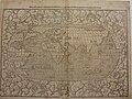
 Map of ancient France (1578).jpg 771 × 615; 137 KB
-
 Map of ancient France (1628).jpg 1,024 × 768; 205 KB
-
 Map of Asia (1554).jpg 1,552 × 1,169; 230 KB
-
 Map of Asia (1560) northwest.jpg 800 × 602; 131 KB
-
 Map of Asia (1560) outhwest.jpg 800 × 602; 146 KB
-
 Map of Asia (1560) southeast.jpg 800 × 602; 156 KB
-
 Map of Asia (1560).jpg 800 × 628; 138 KB
-
 Map of Asia (1569) North East.jpg 800 × 600; 141 KB
-
 Map of Asia (1569) North West.jpg 800 × 600; 132 KB
-
 Map of Asia (1569) South East.jpg 800 × 600; 150 KB
-
 Map of Asia (1569) South West.jpg 800 × 600; 142 KB
-
 Map of Asia (1569).jpg 800 × 600; 131 KB
-
 Map of Asia (1588) South Asia.jpg 800 × 600; 136 KB
-
 Map of Asia (1588).jpg 800 × 600; 127 KB
-
 Map of Asia (1628) North east.jpg 800 × 600; 147 KB
-
 Map of Asia (1628) North West.jpg 800 × 600; 158 KB
-
 Map of Asia (1628) South east.jpg 800 × 600; 156 KB
-
 Map of Asia (1628) South west.jpg 800 × 600; 141 KB
-
 Map of Asia (1628).jpg 800 × 600; 135 KB
-
 Map of Asia a closer view(1554).jpg 1,600 × 1,200; 328 KB
-
 Map of Asia and the Americas (1588).jpg 860 × 645; 243 KB
-
 Map of Asia* (1560) northeast.jpg 800 × 602; 135 KB
-
 Map of Bavaria-Franconia Small.jpg 800 × 600; 160 KB
-
 Map of Creete (1588).jpg 800 × 483; 117 KB
-
 Map of Eastern Europe (1628).jpg 1,024 × 768; 197 KB
-
 Map of Egypt (1578).jpg 976 × 914; 230 KB
-
 Map of Egypt (1580) a closer view.jpg 800 × 1,067; 214 KB
-
 Map of Egypt (1580).jpg 800 × 1,067; 169 KB
-
 Map of Famagusta, Sebastian Münster, 1578.jpg 2,047 × 2,709; 2.21 MB
-
 Map of France (1574).jpg 1,137 × 963; 319 KB
-
 Map of Italy(1588) south east.jpg 800 × 466; 79 KB
-
 Map of Rome 1628.jpg 1,024 × 768; 155 KB
-
 Map of Taprobana (1574).jpg 1,212 × 1,038; 389 KB
-
 Map of the ancient world* (1555) .jpg 1,694 × 800; 307 KB
-
 Map of the British Isles (1578).jpg 1,118 × 901; 225 KB
-
 Map of the Deccan and the south (c.1588).jpg 800 × 634; 158 KB
-
 Map of the northern hemisphere (Ptolemaic) (1553).jpg 800 × 600; 219 KB
-
 Map of the northern hemisphere (Ptolemaic) east half (1553).jpg 800 × 1,067; 327 KB
-
 Map of the northern hemisphere (Ptolemaic) west half (1553).jpg 800 × 1,067; 325 KB
-
 Map of the world (1588).jpg 800 × 600; 145 KB
-
 Map of the world eastern hemisphere(1588).jpg 800 × 600; 154 KB
-
 Map of the world including the New World (1553).jpg 800 × 600; 211 KB
-
 Map of the world including the New World east half(1553).jpg 800 × 1,067; 311 KB
-
 Map of the world including the New World Wst half(1553).jpg 800 × 1,067; 322 KB
-
 Map of the world North east(1580).jpg 800 × 600; 155 KB
-
 Map of the world North West(1580).jpg 800 × 600; 153 KB
-
 Map of the world South east (1580).jpg 800 × 600; 134 KB
-
 Map of the world South West (1580).jpg 800 × 600; 129 KB
-
 Map of the world western hemisphere(1588).jpg 800 × 600; 148 KB
-
 Map of the world*(1580).jpg 800 × 600; 134 KB
-
 Map of Trieste 1600.jpg 800 × 600; 156 KB
-
 Map of Tunis (1628).jpg 768 × 1,024; 212 KB
-
 Map of Turkey (1600) a closer view.jpg 800 × 600; 155 KB
-
 Map of Wallisserland, Switzerland (1600) a detail.jpg 800 × 1,067; 264 KB
-
 Map of Western Switzerland (1600) a closer view.jpg 637 × 593; 142 KB
-
 Map Swabia small 1600.jpg 800 × 600; 143 KB
-

-
 Marburg 1600.jpg 800 × 600; 161 KB
-
 Mecheln, Belgium (1600).jpg 800 × 600; 135 KB
-
 Meissen 1600 detail1.jpg 800 × 600; 165 KB
-
 Meissen 1600 detail2.jpg 800 × 600; 149 KB
-
 Meissen 1600.jpg 800 × 600; 166 KB
-
 Melita map by Sebastian Munster (Basel, ca. 1550).jpg 442 × 672; 129 KB
-
 Midnightlands.jpg 1,024 × 799; 147 KB
-
 Milan 1600.jpg 800 × 600; 172 KB
-
 Mirandola - Italy under attack (1600).jpg 800 × 600; 151 KB
-
 Montpellier Centre (1600).jpg 800 × 600; 157 KB
-
 Montpellier Left (1600).jpg 800 × 600; 153 KB
-
 Montpellier Right (1600).jpg 800 × 600; 156 KB
-

-
 Munich, Bavaria (1600) a closer view.jpg 800 × 600; 144 KB
-
 Munster Algiers.tif 2,527 × 1,983; 12.3 MB
-
 Munster C1570 Hand col Woodcut. Algeria, Algiers.jpg 1,050 × 788; 311 KB
-
 MunsterBM.jpg 2,362 × 1,540; 1.1 MB
-
 Münster , Sebastian. Eyfalia (1550).jpeg 1,724 × 2,756; 1.26 MB
-
 Münster Schwaben.jpg 800 × 545; 290 KB
-
 Native warfare in Mexico (Montezuma) (1628).jpg 1,024 × 768; 197 KB
-
 Neuenberg 1600.jpg 800 × 600; 149 KB
-
 AFRICA XXV NOVA TABULA.jpg 1,770 × 1,404; 1.06 MB
-
 Nordlingen, Bavaria (1600) lower left.jpg 800 × 600; 151 KB
-
 Nordlingen, Bavaria (1600) upper center.jpg 800 × 600; 158 KB
-
 Nordlingen, Bavaria (1600) upper left.jpg 800 × 600; 146 KB
-
 Nordlingen, Bavaria (1600)lower right.jpg 800 × 600; 147 KB
-
 Nordlingen, Bavaria* (1574).jpg 1,104 × 900; 321 KB
-
 Novae insvlae XXVI nova tabvla. NYPL1260170.tiff 4,308 × 3,541; 43.65 MB
-
 Nuremberg, Bavaria (1600).jpg 800 × 1,067; 172 KB
-
 Nuremberg, Bavaria* (1600); *a closer view.jpg 800 × 600; 149 KB
-
 Offenburg 1600.jpg 800 × 600; 157 KB
-
 Orange (1600).jpg 800 × 600; 132 KB
-
 Parma under military attack (1600).jpg 800 × 600; 159 KB
-
 Parma under military attack (1600); a closer view.jpg 800 × 600; 163 KB
-
 Perpignon (1600).jpg 800 × 600; 160 KB
-
 PG UFL2.jpg 1,126 × 982; 982 KB
-
 Poitiers (1600).jpg 800 × 600; 155 KB
-
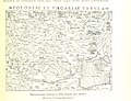
 Poloniae et Ungariae Münstera.jpg 1,000 × 786; 324 KB
-
 Poloniae et Ungariae zMünstera.jpg 2,328 × 1,840; 1.49 MB
-
 Prague (1600).jpg 800 × 600; 156 KB
-
 Ptolemaisch General Tafel.JPG 2,380 × 1,750; 4.28 MB
-
 Regensburg, Bavaria* (1600).jpg 800 × 600; 149 KB
-
 Regensburg-Sebastian-Muenster-1574.jpg 1,000 × 804; 703 KB
-
 Regina Europa from Cosmographia by Sebastian Münster.jpg 945 × 1,323; 1.72 MB
-
 Regina Europa from Sebastian Münster's Cosmographia.jpg 945 × 1,429; 1.45 MB
-
 Rhodes (1600).jpg 800 × 600; 155 KB
-
 Riga (Cosmographia (Sebastian Münster)).jpg 731 × 474; 100 KB
-
 Riga wodcut 1575.gif 1,936 × 1,242; 134 KB
-
 Rome 1578.jpg 1,104 × 919; 211 KB
-
 Rufach, Alsace (1574).jpg 1,239 × 1,005; 443 KB
-
 Russland, Polen und Livland bis ins 17. Jahrhundert (1886) (14783601485).jpg 2,316 × 3,404; 1.8 MB
-
 Schonlandia - no-nb krt 00486.jpg 4,539 × 3,568; 3.55 MB
-
 Sebastian Muenster 1544.jpg 2,000 × 1,700; 1.19 MB
-
 Sebastian Munster - Tabula europae IX (Dacia).jpg 640 × 499; 86 KB
-
 Sebastian munster 1550 speyer.jpeg 3,248 × 1,763; 1.22 MB
-
 Sebastian munster 1550 wurzburg.jpeg 2,805 × 2,116; 1.89 MB
-
 Sebastian Münster - Map 18 Northern Europe - 1545.jpg 4,222 × 3,181; 1.93 MB
-
 Sebastian Münster - Midnight Lands - 1544.jpg 4,713 × 3,534; 2.07 MB
-
 Sebastian Münster, Cosmographia- Gdańsk, Gniezno, Poznań, Toruń.png 310 × 463; 58 KB
-
-
 Sebastian Münster, Der schonen...Genua, mappa di Genova, Cosmographiae Universalis, 1544.jpg 1,528 × 1,019; 1.53 MB
-

-
 Selestat (1574).jpg 1,215 × 1,020; 359 KB
-
 Si0157x1024.jpg 1,024 × 771; 314 KB
-
 Speyer 1550.jpg 2,946 × 1,956; 3.06 MB
-
 Speyer, Bavaria (1574).jpg 1,010 × 834; 268 KB
-
 Stadtansicht 01.jpg 1,128 × 908; 271 KB
-
 Stadtansicht-kempten.jpg 2,500 × 2,027; 5.08 MB
-
 Tabula Europae IX.jpg 1,624 × 1,280; 2.13 MB
-
 Tartaria & Asistic Sarmatia. Cosmographia. Sebastian Münster.jpg 480 × 800; 77 KB
-
 Tours (1600).jpg 800 × 600; 179 KB
-
 Tours a CloserView (1600).jpg 800 × 600; 193 KB
%27_(11302239363).jpg)
%27_(11303659015).jpg)


.jpg)

.jpg)


.jpg)


.jpg)
.jpg)


_center.jpg)
_left.jpg)
_right.jpg)


_center.jpg)
_left.jpg)
_right.jpg)


.jpg)
_a_closer_view.jpg)


_a_closer_view.jpg)


.jpg)
_center.jpg)


.jpg)
_.jpg)
_.jpg)
.jpg)
.jpg)
.jpg)
.jpg)
_northwest.jpg)
_outhwest.jpg)
_southeast.jpg)
.jpg)
_North_East.jpg)
_North_West.jpg)
_South_East.jpg)
_South_West.jpg)
.jpg)
_South_Asia.jpg)
.jpg)
_North_east.jpg)
_North_West.jpg)
_South_east.jpg)
_South_west.jpg)
.jpg)
.jpg)
.jpg)
_northeast.jpg)

.jpg)
.jpg)
.jpg)
_a_closer_view.jpg)
.jpg)

.jpg)
_south_east.jpg)

.jpg)
_.jpg)
.jpg)
.jpg)
_(1553).jpg)
_east_half_(1553).jpg)
_west_half_(1553).jpg)
.jpg)
.jpg)
.jpg)
.jpg)
.jpg)
.jpg)
.jpg)
.jpg)
.jpg)
.jpg)
.jpg)

.jpg)
_a_closer_view.jpg)
_a_detail.jpg)
_a_closer_view.jpg)


.jpg)


.jpg)


.jpg)
.jpg)
.jpg)
.jpg)
,_etc._(Illustrated.)%27_(11235981274).jpg)
_a_closer_view.jpg)


.jpeg)

_(1628).jpg)


_lower_left.jpg)
_upper_center.jpg)
_upper_left.jpg)
lower_right.jpg)
.jpg)
.jpg)
;_*a_closer_view.jpg)

.jpg)
.jpg)
;_a_closer_view.jpg)
.jpg)

.jpg)


.jpg)

.jpg)


.jpg)
).jpg)


.jpg)
_(14783601485).jpg)


.jpg)


.jpg)


.jpg)


.jpg)
.jpg)
&filefrom=Tours+a+detail+%281600%29.jpg#mw-category-media)