Category:Maps by Sidney Hall
Jump to navigation
Jump to search
Media in category "Maps by Sidney Hall"
The following 7 files are in this category, out of 7 total.
-
 Hall Africa 1840 UTA.jpg 1,600 × 2,236; 2.47 MB
-
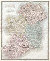 1850 Hall Map of Ireland - Geographicus - Ireland-hall-1850.jpg 4,000 × 4,856; 6.3 MB
-
 Canada, New Brunswick and Nova Scotia by Sidney Hall CTASC.jpg 600 × 495; 332 KB
-
 Sidney Hall - South America.jpg 2,366 × 2,995; 2.01 MB
-
 Sidney Hall 1830 map of Palestine showing Ottoman divisions.jpg 5,310 × 6,488; 6.14 MB
-
 SidneyHall Denmark 1830-Longman.jpg 3,568 × 2,465; 5.79 MB
-
 Van Diemen's Land (15202418751).jpg 4,001 × 4,961; 1.57 MB


.jpg)