Category:Maps by Jedidiah Morse
Jump to navigation
Jump to search
Media in category "Maps by Jedidiah Morse"
The following 45 files are in this category, out of 45 total.
-
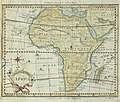 Morse Africa 1796 UTA.jpg 2,455 × 2,083; 1.93 MB
-
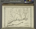 A map of Connecticut. NYPL1567523.tiff 6,598 × 5,428; 102.47 MB
-
 A map of Kentucky, drawn from actual observations by John Filson. NYPL1567531.tiff 5,428 × 7,230; 112.28 MB
-
 A map of Massachusets (sic) from the best authorities. NYPL1567521.tiff 6,598 × 5,428; 102.47 MB
-
 A map of New Hampshire. NYPL1567520.tiff 5,428 × 6,598; 102.47 MB
-
 A map of New Jersey, from the best authorities. NYPL1567525.tiff 5,428 × 6,598; 102.47 MB
-
 A map of Newfoundland. NYPL1567517.tiff 5,428 × 6,598; 102.47 MB
-
 A map of North Carolina - from the best authorities LOC 2014588268.jpg 5,111 × 3,143; 2.21 MB
-
 A map of North Carolina - from the best authorities LOC 2014588268.tif 5,111 × 3,143; 45.96 MB
-
 A map of North Carolina, from the best authorities. NYPL1567532.tiff 7,230 × 5,428; 112.28 MB
-
 A map of North Carolina.jpg 5,140 × 2,731; 1.33 MB
-
 A map of Pennsylvania, from the best authorities. NYPL1567526.tiff 6,598 × 5,428; 102.47 MB
-
 A map of Rhode Island. NYPL1567522.tiff 5,428 × 6,598; 102.47 MB
-
 A map of South America and the adjacent islands, 1794. NYPL1567536.tiff 6,598 × 5,428; 102.47 MB
-
 A map of South Carolina, from the best authorities. NYPL1567534.tiff 7,230 × 5,428; 112.28 MB
-
 A map of the Back Settlements. NYPL1567530.tiff 6,598 × 5,428; 102.47 MB
-
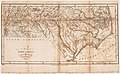
 A map of the East and West Florida. NYPL1567535.tiff 6,598 × 5,428; 102.47 MB
-
 A map of the State of New York. NYPL1567524.tiff 5,428 × 6,598; 102.47 MB
-

-
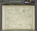
 A map of the Tennessee Government, 1794. NYPL1567533.tiff 6,598 × 5,428; 102.47 MB
-
 A map of the West Indies, from the best authorities. NYPL1567537.tiff 7,230 × 5,428; 112.28 MB
-
 A map of the world, exhibiting all the new discoveries, 1794. NYPL1567538.tiff 6,598 × 5,428; 102.47 MB
-
 A map of Vermont. NYPL1567519.tiff 5,428 × 6,598; 102.47 MB
-
 A new map of North America from the latest and best authorities, 1794. NYPL1567514.tiff 6,598 × 5,428; 102.47 MB
-
 A new map of Nova Scotia, New Brunswick and Cape Breton, 1794. NYPL1567516.tiff 6,598 × 5,428; 102.47 MB
-
 A new map of Upper and Lower Canada, 1794. NYPL1567515.tiff 6,598 × 5,428; 102.47 MB
-
 Alexandria Winchester 1794.jpg 914 × 572; 192 KB
-
 Houghton EducT 247.84 (A) - Morse, Map of the United States.jpg 2,561 × 2,597; 3.01 MB
-
 North America. NYPL465038.tiff 4,040 × 4,490; 51.92 MB
-
 Map of the United States of America (NYPL b15072779-434049).tiff 4,000 × 3,093; 35.4 MB
-
 Map of the northern parts of the United States of America (NYPL b15079258-434052).jpg 5,530 × 3,888; 4.62 MB
-
 Map of the northern parts of the United States of America (NYPL b15079258-434052).tiff 5,530 × 3,888; 61.52 MB
-
 United States (NYPL b15110715-434041).jpg 5,824 × 4,168; 5.7 MB
-
 Map of Virginia, Maryland and Delaware (NYPL b15317432-976263).jpg 6,251 × 4,080; 4.86 MB
-
 Map of Virginia, Maryland and Delaware (NYPL b15317432-976263).tiff 6,251 × 4,080; 72.97 MB
-
 North America (NYPL b15405506-465038).jpg 4,032 × 4,480; 3.71 MB
-
 Plan of the city of Washington. LOC 88694118.jpg 2,941 × 2,232; 1.07 MB
-
 Plan of the city of Washington. LOC 88694118.tif 2,941 × 2,232; 18.78 MB
-

-

-
 United States. NYPL434041.tiff 4,168 × 5,835; 69.59 MB
-
 US map JedidiahMorse ca1824 engr byAnnin and Smith NYPL.jpeg 697 × 422; 192 KB
-
 Washington DC 1794-.jpg 3,593 × 2,791; 1.19 MB
-
 Washington DC 1794.jpg 4,615 × 4,012; 3.25 MB
-
 Western Hemisphere. NYPL1260096.tiff 3,496 × 3,460; 34.64 MB


_-_Morse,_Map_of_the_United_States.jpg)
.jpg)
.jpg)
.jpg)
.jpg)


.jpg)


