Category:Map of Western Palestine in 26 sheets (PEF)
Jump to navigation
Jump to search
The Map of Western Palestine in 26 sheets stems from the surveys conducted for the Committee of the en:Palestine Exploration Fund (PEF) by Lieutenants en:Claude Reignier Conder and en:Herbert Kitchener, 1st Earl Kitchener, during the years 1872-1877. The maps were subsequently produced from 1878-1881 and then published as part of an 1881-1882 survey documentation. Additional print runs for the whole map were made (with slight alterations in content, and even inclusion of Lebanon and Transjordan) in 1897 and 1917.
Overview / Index
(Hover the tiles to see sheet number)
![]()
![]()
.jpg)
.jpg)
![]()
![]()
.jpg)
.jpg)
![]()
![]()
.jpg)
.jpg)
![]()
.jpg)
.jpg)
.jpg)
![]()
.jpg)
.jpg)
.jpg)
![]()
.jpg)
.jpg)
.jpg)
![]()
.jpg)
.jpg)
.jpg)
.jpg)
.jpg)
.jpg)
.jpg)
.jpg)
.jpg)
.jpg)
.jpg)
Subcategories
This category has the following 22 subcategories, out of 22 total.
Media in category "Map of Western Palestine in 26 sheets (PEF)"
The following 21 files are in this category, out of 21 total.
-
-

-
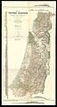
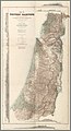
 Index map to the 1917-18 version of Conder's PEF map.jpg 664 × 1,161; 1.15 MB
-

-

-

-

-

-
-

-

-

-

-
 PEF Survey of Western Palestine composite showing Natural Drainage and Mountain Ranges.jpg 7,230 × 13,385; 16.14 MB
-
 PEF Survey of Western Palestine composite.jpg 7,253 × 12,428; 14.47 MB
-
 PEF Survey of Western Palestine Key Map.png 10,976 × 9,122; 74.8 MB
-
 PEF Survey of Western Palestine showing the New Testament.jpg 7,194 × 12,319; 13.06 MB
-
 PEF Survey of Western Palestine showing the Old Testament.jpg 7,226 × 12,361; 13.58 MB
-
 PikiWiki Israel 19901 Palestine Exploration Fund Map 1879.jpg 2,119 × 2,957; 9.95 MB
-
 Survey of Western Palestine 1880.0i.jpg 2,693 × 2,309; 403 KB
-
 Survey of Western Palestine 1880.0ii.jpg 2,721 × 2,307; 549 KB
.jpg)
.jpg)

.jpg)
.jpg)
.jpg)
.jpg)
.jpg)
.jpg)
.jpg)
.jpg)
.jpg)
.jpg)


