Category:Maine State Route 27
Jump to navigation
Jump to search
 | number: | (twenty-seven) |
|---|---|---|
| State highways in Maine: | 7 · 8 · 9 · 11 · 15 · 16 · 17 · 22 · 24 · 25 · 26 · 27 · 32 · 35 · 41 · 43 |
State highway in Maine, US  | |||||
| Upload media | |||||
| Instance of | |||||
|---|---|---|---|---|---|
| Location | Maine | ||||
| Transport network |
| ||||
| Owned by | |||||
| Maintained by | |||||
| Inception |
| ||||
| Length |
| ||||
| |||||
Media in category "Maine State Route 27"
The following 12 files are in this category, out of 12 total.
-
 Arnold Trail.jpg 967 × 659; 80 KB
-
 Cranberry Peak Seen From Maine State Route 27.JPG 1,800 × 1,200; 638 KB
-
 Frontierecoburngore.jpg 2,428 × 1,728; 422 KB
-
 Maine 27.svg 601 × 601; 3 KB
-
 Maine State Route 27 map.svg 1,204 × 708; 469 KB
-
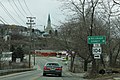
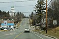
 Maine State Routes 16 and 27 in downtown Kingfield.JPG 1,800 × 1,200; 466 KB
-
 ME41nAtUS2ME27-NearNewSharon (35759552382).jpg 2,400 × 1,600; 1.89 MB
-
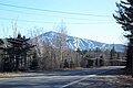 Sugarloaf Mountain seen from Maine State Route 27.JPG 1,800 × 1,200; 806 KB
-
 ToME104signRoad-Augusta (35759623992).jpg 2,400 × 1,600; 2.66 MB
-
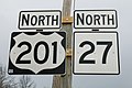 US201 and ME27 Signs (35797756031).jpg 2,400 × 1,600; 1.73 MB
-
 US201nME27nRoad-Augusta (35888910516).jpg 2,400 × 1,600; 2.42 MB
-
 US2eME27sME41sME156sign (35888862216).jpg 2,400 × 1,600; 2.35 MB


.jpg)

.jpg)
.jpg)
.jpg)
.jpg)