Category:Luthereiche (Bad Homburg)
Jump to navigation
Jump to search
| Object location | | View all coordinates using: OpenStreetMap |
|---|

| Upload media | |||||
 | |||||
![]() Germany
Germany ![]() Hesse
Hesse ![]() Hochtaunuskreis
Hochtaunuskreis ![]() Bad Homburg vor der Höhe - 340 m ü. NHN
Bad Homburg vor der Höhe - 340 m ü. NHN
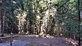
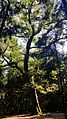
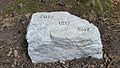
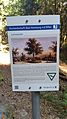
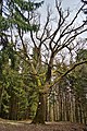
Deutsch: Naturdenkmal in Bad Homburg vor der Höhe. Die Luthereiche steht in Bad Homburg, Ortsteil Dornholzhausen, am König-Wilhelms-Weg. Sie wurde am 31. Oktober 1817 gepflanzt. 1993 betrug der Stammumfang ca. 2,5 m, der Durchmesser fast 1 m und die Baumhöhe über 20 m. 2016 schätzte Stadtförster Günter Busch die Höhe der Traubeneiche (Quercus petraea) auf gut 18 m bei einem Umfang von 3,30 m. Naturdenkmal seit 1938.
Media in category "Luthereiche (Bad Homburg)"
The following 12 files are in this category, out of 12 total.
-
 Luthereiche Bad Homburg 160924 01.jpg 2,988 × 5,312; 6.2 MB
-
 Luthereiche Bad Homburg 160924 02.jpg 2,988 × 5,312; 8.02 MB
-
 Luthereiche Bad Homburg 160924 03.jpg 2,988 × 3,984; 6.46 MB
-
 Luthereiche Bad Homburg 160924 04.jpg 5,312 × 2,988; 6.45 MB
-
 Luthereiche Bad Homburg 160924 05.jpg 5,312 × 2,988; 7.39 MB
-
 Luthereiche Bad Homburg 160924 06.jpg 2,988 × 5,312; 7.5 MB
-
 Luthereiche Bad Homburg 160924 07.jpg 2,988 × 5,312; 7.08 MB
-
 Luthereiche Bad Homburg 160924 08.jpg 5,312 × 2,988; 7.13 MB
-
 Luthereiche Bad Homburg 160924 09.jpg 3,984 × 2,988; 4.45 MB
-
 Luthereiche Bad Homburg 160924 10.jpg 5,312 × 2,988; 3.77 MB
-
 Luthereiche Bad Homburg 160924 11.jpg 2,988 × 5,312; 4.08 MB
-
 Luthereiche-Hochtaunus.jpg 2,832 × 4,240; 9.24 MB


