Category:Lord Burghley's Atlas (1579) - BL Royal MS 18 D III
Jump to navigation
Jump to search
proof maps from Christopher Saxton's Atlas of the Counties of England and Wales, annotated and bound together with additional printed and hand-drawn maps, for the use of William Cecil, Lord Burghley ,_ff.11v-12_-_BL_Royal_MS_18_D_III.jpg) Annotated proof map of Devon from Lord Burghley's Atlas (1579), ff.11v-12 | |||||
| Upload media | |||||
| Instance of |
| ||||
|---|---|---|---|---|---|
| Edition or translation of |
| ||||
| Made from material | |||||
| Location | British Library, Thorp Arch Trading Estate, Walton, Leeds, West Yorkshire, Yorkshire and the Humber, England | ||||
| Author | |||||
| Creator | |||||
| Language of work or name | |||||
| Full work available at URL | |||||
| Owned by | |||||
| Collection |
| ||||
| Inventory number |
| ||||
| Inception |
| ||||
| Width |
| ||||
| Height |
| ||||
| |||||
- Catalogue entry: Royal MS 18 D III
- "Online Gallery" search - MSS blog search - "Images online" search
Media in category "Lord Burghley's Atlas (1579) - BL Royal MS 18 D III"
The following 9 files are in this category, out of 9 total.
-
 Devon - Lord Burghley's Atlas (1579), ff.11v-12 - BL Royal MS 18 D III.jpg 1,574 × 1,215; 1,000 KB
-
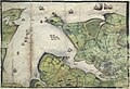 Falmouth Harbour - Lord Burghley's Atlas (1579), ff.15v-16 - BL Royal MS 18 D III.jpg 1,784 × 1,222; 981 KB
-

-
 Northumberland - Lord Burghley's Atlas (1579), ff.71v-72 - BL Royal MS 18 D III.jpg 1,504 × 1,171; 991 KB
-
 Wales and Anglesey - Lord Burghley's Atlas (1579), ff.98v-99 - BL Royal MS 18 D III.jpg 1,505 × 1,215; 933 KB
-

-

-

-

,_ff.15v-16_-_BL_Royal_MS_18_D_III.jpg)
,_ff.71v-72_-_BL_Royal_MS_18_D_III_-_coat_of_arms_of_Thomas_Seckford.jpg)
,_ff.71v-72_-_BL_Royal_MS_18_D_III.jpg)
,_ff.98v-99_-_BL_Royal_MS_18_D_III.jpg)
,_f._10r_-_BL_Royal_MS_18_D_III.png)
,_ff.15v-16_-_BL_Royal_MS_18_D_III.png)
,_f._10r_-_BL_Royal_MS_18_D_III_(cropped).png)
