Category:Ligne fortifiée dite Wotan Stellung (Allennes-les-Marais)
Jump to navigation
Jump to search
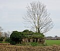
Ces six casemates alignées sur quelques 800 sont les vestiges la mise en place de la Wotan Stellung (position Wotan), par les allemands vers 1917.
|
This building is indexed in the base Mérimée, a database of architectural heritage maintained by the French Ministry of Culture, under the references IA59004788
|
| Camera location | | View all coordinates using: OpenStreetMap |
|---|
defence line in France  | |||||
| Upload media | |||||
| Instance of | |||||
|---|---|---|---|---|---|
| Location | Nord, Hauts-de-France, Metropolitan France, France | ||||
| Heritage designation | |||||
 | |||||
Media in category "Ligne fortifiée dite Wotan Stellung (Allennes-les-Marais)"
The following 3 files are in this category, out of 3 total.
-
 Allennes-les-Marais Casemate à mitrailleuse 2024.jpg 3,245 × 2,753; 6.02 MB
-
 Allennes-les-Marais Casemate à mitrailleuse 212 IA59004788.jpg 4,731 × 2,042; 4.14 MB
-
 Allennes-les-Marais Casemate à mitrailleuse 212.jpg 4,896 × 3,672; 7.57 MB

